Wednesday, October 30, 2013

Tackling governance of geoscience cyberinfrastructure

"Imagine a world with unlimited access to scientific data in any field, where researchers can plot data from any source and visualize it any way they'd like, and where they can model results and explore ideas from a desktop, a lab or the field.

EarthCube aims to make that vision a reality.

EarthCube is a National Science Foundation (NSF) effort to create a data and knowledge management system for geosciences in the 21st century.

Its objective is to develop new ways of understanding and predicting the Earth system, from the sun to the center of the Earth.

To foster a dialog among geo-, bio- and cyberscientists to create an EarthCube framework, NSF has made 13 new awards totalling $14.5 million."       [NSF news release]

I will lead the largest project, to develop a governing structure to facilitate agreement on system design and standards integration.     The biggest challenges to building an effective cyberinfrastructure over the past decade have not been technical, but rather organizational, cultural, and institutional.    We are bringing in social scientists to work with geoscientists and computer scientists to find ways past the barriers that have held us back.  We will be testing methods to crowdsource an organizational structure that the community has a stake in and is flexible to respond to this quickly developing field.

The EarthCube governance award is to the University of Arizona where I am an adjunct professor in the Geosciences Dept. but the bulk of the work will be carried out by a virtual team scattered around the country and coordinated by our team at the Arizona Geological Survey.

The NSF announcement also said
Scientists who specialize in governance; data discovery, mining and access; workflows and other fields are participating. We're in an era when access to information and data is often less a problem than the ability to efficiently process and use it, geoscientists say. In some cases, the problem is caused by huge datasets that are difficult to store, transfer or analyze. In other cases, the challenge is discovering and aggregating relevant data widely disseminated in many locations and formats, such as in the tables, text and figures of published papers, government agency reports, spreadsheets and websites.  A central EarthCube goal is establishing a computing system that can aid in finding, extracting and aggregating data, as well as in processing, summarizing and synthesizing those data in ways that help geoscientists better understand and model Earth systems.

2013 NSF EarthCube Awards:
Yolanda Gil, University of Southern California: EarthCube building blocks: Software stewardship for the geosciences

Kerstin Lehnert, Columbia University, Lamont Doherty Earth Observatory: EarthCube RCN: CP4: Collaboration and cyberinfrastructure for paleogeosciences

Matty Mookerjee, Sonoma State University: EC3: Earth-centered communication for cyberinfrastructure: Challenges of field data collection, management, and integration

Wonsuck Kim, University of Texas at Austin: RCN: Building a Sediment Experimentalist Network (SEN)

Tim Ahern, Integrated Research Institutions for Seismology: EarthCube building blocks: Deploying web services across multiple geoscience domains

Christopher Re, Stanford University: EarthCube building blocks: A cognitive computer infrastructure for geoscience

David Maidment, University of Texas at Austin: EarthCube building blocks: Integrating discrete and continuous data

Siri-Johda Khalsa, University of Colorado: EarthCube building blocks: A broker framework for next generation geoscience (BCube)

Scott Peckham, University of Colorado: EarthCube building blocks: Earth system bridge: Spanning scientific communities with interoperable modeling frameworks

Ilya Zaslasky, University of California, San Diego: EarthCube building blocks: Community inventory of EarthCube Resources for Geoscience Interoperability (CINERGI)

David Fulkner, Open Source Project for Network Data Access Protocols: EarthCube building blocks: Specifying and implementing ODSIP, A data-service invocation protocol

Thomas Narock, University of Maryland, Baltimore County: EAGER: Collaborative research: EarthCube building blocks, leveraging semantics and linked data for geoscience data sharing and discovery

Lee Allison, University of Arizona: EarthCube test enterprise Governance: An agile approach


Sunday, October 20, 2013

Freak accident takes life of Phyllis Lindbergh


Phyllis Lindbergh, who was well known throughout the Arizona geologic community as she accompanied her husband, Paul on numerous field trips and lectures, was killed last Thursday by a falling tree while hiking.

Colleagues report she was hiking with four friends, sat down for lunch, and a ponderosa pine tree fell over and killed her instantly. She and Paul had just been with the Central Arizona Geology Club on their Flagstaff field trip the previous Saturday. 

Our deepest sympathies go out to Paul and family.

Detour around US89 landslide now fully open


The Arizona Dept. of Transportation reports that the newly paved, shorter US 89 detour route in northern Arizona is now fully open with no restrictions after ADOT completed fencing along the corridor to help prevent livestock from crossing the roadway.  [Right, ADOT photo of US 89 landslide right after its occurrence]

Until now, the Temporary US 89 (US 89T), opened with limited access on Aug. 29, was limited to only daytime use and speed restrictions were present in areas where the fencing had yet to be completed. The maximum speed limit for the corridor is now 55 mph.

The 44-mile-long US 89T route runs parallel to US 89 from The Gap to LeChee and is accessible from US 89, approximately 17 miles north of the US 160 junction (Tuba City exit). Previously a Navajo Nation roadway, US 89T will be maintained by ADOT while it is in use as a detour.

The US 89T project became necessary after a Feb. 20 landslide closed a section of US 89 between Bitter Springs and Page. Prior to paving US 89T, drivers headed to and from Page were forced to take a 115-mile-long alternate route along US 160 and State Route 98.
When traveling on US 89T, ADOT urges motorists to slow down, pay attention to their surroundings and be aware that this roadway on the Navajo Nation is prone to animal crossings, including horses, goats, cows and dogs.

US 89T is not part of the ultimate solution to repair US 89, which suffered a landslide that buckled pavement along the mountain slope in the Echo Cliffs area.

The projected $40 million repair is already on the fast track. Design on the repair began in late August and ADOT is meeting with potential contractors this fall. ADOT’s goal is to start construction by mid-2014, if extensive environmental and right-of-way clearances are finalized. 

To learn more about the landslide, the geotechnical survey and the ultimate solution for US 89, please visit the project’s web page at www.azdot.gov/us89, or call the ADOT Project Hotline at 855.712.8530, or email at Projects@azdot.gov.

[reprinted from the ADOT news release]

Remembering Walt Heinrichs


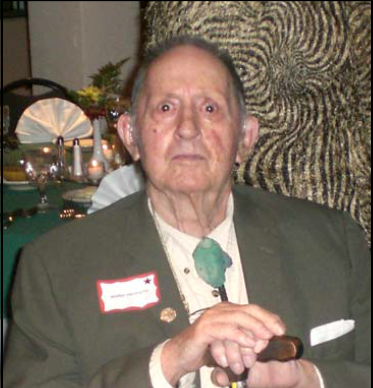
The geologic community is mourning the loss of Walt Heinrichs. A memorial service is scheduled for Sunday, October 27, at 1:30 pm.  [Photo credit, Arizona Geological Society]

Location: Grace Evangelical Covenant Church
Address: 9755 N. La Cholla Blvd. (between Overton and Lambert north of the bridge construction)

David Briggs published a commemoration to recognize Walt's contributions to understanding the region's geology, at http://tucsoncitizen.com/miningandyou/2013/10/19/discovery-of-pima-mission-copper-mine-pima-county-arizona/

There will be an obituary in the Arizona Daily Star this Sunday, Oct. 20.

Walt was cremated and his ashes will be scattered in Colorado with those of his first wife Jean.
If you have any photos you’d like to share with Fred, please send him at skierfwh@gmail.com

 Cori Hoag forwarded the text from the bio for his 1993 American Mining Hall of Fame Medal of Merit, below:


1993 MEDAL OF MERIT RECIPIENT, AMERICAN MINING HALL OF FAME
Walt Heinrichs was born in Superior, Arizona, and was raised in the mining camps of the western United States and in the Philippines. He graduated from the Colorado School of Mines in 1940 as a geological engineer with a geophysics major. After service in the U.S. Navy's early Gulf Coast off-shore aerial magnetometer experiments, he worked as a geophysicist with the U.S. Bureau of Reclamation and then with Newmont Mining Corporation.

Heinrichs is one of the pioneers of modem mining geophysical exploration and is credited with being a key member of the United Geophysical Company team under Herbert Hoover, Jr., that discovered the Pima mine using geophysics in an area long considered to be “non-mineral”.

In 1955, he was the co-recipient of the AIME's “Robert Peele Memorial Award” for his part in a paper related to the discovery of the Pima Mine. In that same year, he received the Colorado School of Mines first “Van Diest Award” for outstanding work during the first 15 years following graduation.

In 1958, he co-founded Heinrichs GEOEXploration Company, which he still owns and manages. GEOEX continues to provide geophysical consulting services in water, energy, minerals and environmental matters.