Saturday, August 28, 2010

ASU pushes back age of Solar System, explains origin


An ASU press release announces that the "Arizona State University researchers Audrey Bouvier and Meenakshi Wadhwa [Center for Meteorite Studies] analyzed meteorite Northwest Africa (NWA) 2364 and found that the age of the Solar System predates previous estimates by up to 1.9 million years." [right, Audrey Bouvier in the age dating lab at ASU. Credit, Audrey Bouvier]

"The study’s findings, published online on August 22 in Nature Geoscience, fix the age of the Solar System at 4.5682 billion years old..."

While this sounds like a minor adjustment, Dr. Wadhwa says it means that there was "as much as twice the amount of iron-60, a certain short-lived isotope of iron, in the early Solar System than previously determined," which can only be explained as coming from a supernova, that he suggests was a cause of the Solar System formation.

Friday, August 27, 2010

How do you count uranium mines?

Roger Clark of the Grand Canyon Trust told the Arizona Republic newspaper that there will be 100 uranium mines around the Grand Canyon, turning it into a industrial zone. Dr. Madan Singh, Director of the Arizona Dept. of Mines & Mineral Resources, wrote a letter to the editor that countered "During the period 1980 to 1991, there were seven uranium mines that operated in the area. There is no evidence of damage to the air, water, wildlife or human health."

[top right, photo of the Piegon Mine in operation, Nov. 1989. Bottom right, after reclamation, Oct. 1993. Photo credit, Pam Hill. Taken from Karen Wenrich's testimony - see below]

Roger Clark posted a comment to Madan's letter explaining how he calculated the 100 mines:
"On July 21, 2009, Arizona State Director of the Department of Mines Mandan Singh testified before Congress that "...there will be approximately six(6) mines in operation at any one time and another six (6) being reclaimed over roughly a 20 year period." http://resourcescommittee.h...
Six mines per year for 20 years equals more than 100 uranium mines of 20 acres in size or larger within watersheds that drain directly into the Grand Canyon. I stand by my statement in the Republic's story.
Roger Clark
Grand Canyon Trust"

So, it seems pretty clear that Mr. Clark counts each year a mine operates as a separate mine. So, multiplying 6 mines times 20 years equals 120 "mine years." That's a unique interpretation. Or perhaps he's arguing that 6 mines will be added each year and all will continue on during the full 20 years.

The breccia pipe uranium mines are small (the pipes are typically 300 ft or less across) and will operate for 3-5 years before being reclaimed. If we assume 6 mines operating at any given time, there could be a cumulative total of 25-40 individual mines over a 20 year period, each in operation only a few years. Each mine would then go through a reclamation period.

The 20 acres Mr. Clark refers to must be the total size of the mine site, including buildings and yard, not just the mined breccia pipes themselves.


LEGISLATIVE HEARING ON H.R. 644 – The Subcommittee on National Parks, Forests and Public Lands of the Committee on Natural Resources – July 21, 2009, Uranium Mining in Arizona Breccia Pipes – Environmental, Economic, and Human Impact, Dr. Karen J. Wenrich, Research Geologist, CrystalUnlimited@aol.com


Thursday, August 26, 2010

Flagstaff becoming the city of sandbags


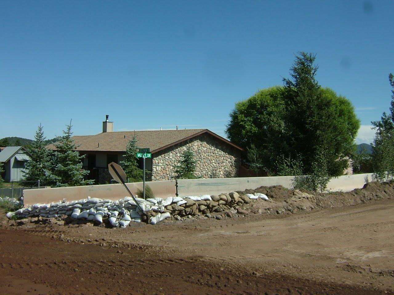
Coconino County public works have erected jersey barriers (concrete wall segments) around nearly 25% of the homes in areas affected by the July 20 flood.

Many more homeowners on the east side of the city have created sandbag barriers around their buildings and across yards or at the upstream point of their properties.

The homes were built on an alluvial fan where sheet flooding is the normal flow pattern. Most homeowners were unaware of the hazard and were caught unprepared when the heavy rains rushed down the slopes above that had been severely burned by the recent Schultz fire.

It's expected that revegetation of the burned area with grasses and low plants will take 3 years or so, during which time the homes are at higher risk of renewed flooding and debris flows.

A quick drive through neighborhoods offers a wide range of homeowner responses. Some have sandbag barriers completely surrounding their homes or outbuildings. Others are blocking doors only, or have one side of their house bagged. We saw lots of barriers that were partially built.

We heard that some residents are worried that their neighbors barriers will divert flood waters onto their properties and into their homes.

Coconino County flood mitigation efforts in Flagstaff


Coconino County is building channels and levees to protect homes on the east side of Flagstaff from future flooding that is exasperated by the Schultz fire that removed stabilizing vegetation above the populated alluvial fan. The county has spent about $2.1 million so far, and the Arizona Div. of Emergency Management has contributed another $2.5 million for the work.

Yesterday, AZGS geologist Ann Youberg was showing me the work she is doing on debris flows from the July 20 storm and it happened that State Emergency Managers were touring mitigation efforts by Coconino County. We tagged along and got to see the work underway on channels, debris basins, and individual home flood protection.

[right, the "Copeland Canal" that extends east from Highway 89. The light colored band on the slope in the background is part of the area burned by the Schultz fire, highlighted in part by the straw dropped by USFS helicopters in hopes of slowing runoff.]


[bottom, county and state emergency officials examine the Cinder Lake dry lake bed where flood runoff is brought by the Copeland Canal which is under construction.]

Debris flow assessment above Flagstaff


AZGS geologist Ann Youberg (right) is in Flagstaff, mapping and assessing the debris flows that accompanied the July 20 flood that damage so many homes in the Timberline and Doney Park subdivisions on the east side of the city. The floods and debris flows were a result of the denuded slopes from the recent Schultz fire.

Ann is working with Dan Neary and his team from the US Forest Service research lab based at NAU. I spent the afternoon in the field with Ann and Karen (USFS) and was astounded at the size of the debris flows on the mid-slopes (below the steep slopes of the upper mountain and above the alluvial fan where people live). [right, Ann Youberg points out the deposition from one debris flow triggered by flooding on July 20]

It's expected that it will take 2-3 years for vegetation to be restored on the upper slopes and naturally mitigate flooding and debris flows. In the meantime, the amount of sediment in channels and swales has the potential to be remobilized into lower channels during heavy rains, affecting how runoff is channeled down the alluvial fan where the residences are.

Tuesday, August 24, 2010

Arizona miners watching lawsuit over Nevada mining claim fee

Small miners across the West, including Arizona, are following the action in Nevada over the mining claim fee enacted by the state legislature earlier this year. An email from Laura Skaer, Executive Director of Northwest Mining Association forwarded a copy of the suit, and she reports that the lawsuit filed in Elko County by Claremont Nevada Mines LLC challenges the constitutionality of the mining claim fee: "The claim fee was included in AB 6 which was enacted to plug an approximately $850 million deficit in the State of Nevada’s budget. The lawsuit seeks a ruling declaring §47 (the claim fee section) of AB 6 violates Article X, Sections 1 and 5 of the Nevada Constitution and is void and unenforceable. It also seeks an injunction against the enforcement of §47 of AB 6 until the court rules on the constitutionality claim."

Reports are circulating in the mining community that other states are considering similar claim fees and taxes on "excess profits of mineral production."

Mining survey - AZ surges, NV dives


Arizona surged from 23rd to 17th in global rankings of areas favorable for mining, while Nevada suffered the biggest drop of any area, falling from 3rd to 10th, largely because of a new mining claim fee and threats of increased production taxes.

"Since 1997, The Fraser Institute has conducted an annual survey of metal mining and exploration companies to assess how mineral endowments and public policy factors such as taxation and regulation affect exploration investment. Survey results represent the opinions of executives and exploration managers in mining and mining consulting companies operating around the world."

Navajos oppose Hopi CO2 sequestration project


The Navajo Nation issued a press release last night announcing that the Tribe's Intergovernmental Relations Committee unanimously passed a resolution opposing the Hopi Tribal Council's "plan to research and allow" for carbon capture sequestration in the Black Mesa Basin. On Aug. 12, the Resources Committee passed the same resolution on a vote of 6-1. [right, WestCarb cross section through the test well previously drilled near the Cholla power plant near Holbrook]

Committee member Raymond Maxx said the Hopi Tribal Council recently approved the $5 million pilot project, working with four utility companies and the U.S. Department of Energy. The pilot project would store carbon dioxide from nearby power plants in an underground storage on Hopi land and near Navajo communities.

"The Hopi Tribal Council has selected a site in the Black Mesa Basin," Maxx said. "The proposed site is near the Navajo Aquifer (N-Aquifer), our precious water source. Once carbon dioxide is injected into the N-Aquifer, it will contaminate the water source we share with the Hopi people, our main underground water supply."

Maxx also said that as neighbors the Hopi Tribal Council failed to consult the Navajo Nation with its proposal. Passage of the resolution also urges the federal government to deny the final implementation of the carbon capture sequestration plan.

The AZGS has a small role in the project being run by the WestCarb consortium on Hopi lands. We will help examine the subsurface geology and evaluate the potential for CO2 storage.

When I was State Geologist of Utah, I ran a DOE-funded project in cooperation with the Navajo Nation to test the use of CO2 injected into small algal mound oil fields for enhanced oil recovery. The giant Aneth field, in the Utah part of the reservation, underwent CO2 injection for decades.

[taken in part from the Navajo Nation news release]

Copper at $10K by 2012?


Credit Suisse is forecasting the price of copper to increase 34% by 2012, reaching a price of $10,000 per tonne or $4.54 per pound according to a story on Mineweb.com. This is predicated on continued economic growth in China (which just passed Japan as the second largest economy in the world) and a modest economic recovery in the West.

If that sounds unrealistic, recall that in the past year, copper rose 150% from $1.30 to $3.30 per lb.

Arizona produces about 65% of the U.S. demand for copper and two potentially huge new mines are seeking regulatory approval to begin mining - Rosemont and Resolution.

Sunday, August 22, 2010

Gigawatts from solar and wind on mine tailings?


An article published today online in Miller-McCune magazine quotes Blair Loftis, national director of alternative and renewable energy for consulting firm Kleinfelder, as saying its possible that one particular mine in Arizona "with 10,000 acres of waste rock and tailings to produce up to 1 gigawatt of combined solar and wind power, about as much as an average coal-fired power plant." He doesn't say which mine.

The idea of using disturbed lands to host renewable energy plants has gained traction recently and the Arizona BLM office has a new program to pursue it. Mine sites often have the infrastructure in place to expedite development - power transmission, heavy duty roads, water sources, etc.

Univ. of Arizona has two experimental sites, at Biosphere 2 and their Sierrita research/teaching mine where the technology is being tested. [right, Nate Allen, sustainability coordinator at Biosphere 2, explains a demonstration site at Biosphere 2 showing how solar panels can be effectively mounted on steep slopes like mine tailings. Credit, UA]

Santa Fe impact structure 5-10 times bigger than Meteor Crater


I guess I missed the article from 2008 that described the evidence for a post-Paleoprotozoic (1.2 bya - 330 mya) impact crater in the area of Santa Fe, New Mexico. A story this month in Astrobiology magazine says the original crater was probably 6-13 km in diameter, or about 5 to 10 times the size of Arizona's Meteor Crater at 1.6 km.

The University of New Mexico is organizing a public field trip for summer 2011 to examine the exposures that document the impact structure. [right, shatter cone outcrop. Credit UNM]

Ref: S. Fackelman, et. al, (2008) “Shatter cone and microscopic shock-alteration evidence for a post-Paleoproterozoic terrestrial impact structure near Santa Fe, New Mexico, USA,” Earth and Planetary Science Letters 270, 290-299.

Governors of oil & gas producing states to meet in Tucson


The Interstate Oil & Gas Compact Commission (IOGCC) is holding its 75th anniversary annual meeting in Tucson in mid-November.

The commission is comprised of 36 oil and gas producing states with a mission of "balancing a multitude of interest-maximizing domestic oil and natural gas production, minimizing the waste of irreplaceable natural resources, and protecting human and environmental health- through sound regulatory practices." The Governor of each state is the official member but they typically appoint one or more representatives.

The meeting will be held Nov. 14-16 at the El Conquistador Hotel & Resort. Current IOGCC Chair Rick Perry, Governor of Texas, will preside.

Dale Nations, head of the AZ Oil & Gas Conservation Commission, is chairing the local host committee for the meeting.

Saturday, August 21, 2010

Peace in Big Chino water war?


The Prescott News quotes City of Prescott Deputy City Manager Craig McConnell as saying the Sierra Club and Center for Biological Diversity are withdrawing their lawsuit against the city over the Big Chino water project. He also said, "...Prescott, Prescott Valley and Salt River Project are filing documents with the court to mutually dismiss litigation according to the agreement we have."

It sounds like the agreement among the cities and Salt River Project to work out their issues cooperatively is coming to fruition. [map credit, City of Prescott]

Friday, August 20, 2010

Mining claim fee pits juniors against majors in Nevada


The battle over a new set of state fees on unpatented mining claims in Nevada appears to pitting the small miner against the majors.

A recently formed Nevada Mineral Exploration Coalition says "Section 47 of Assembly Bill 6 enacted by the Special Session of the Nevada Legislature (the Act)... increased the fee payable by the owner of an unpatented mining claim on the recording of a notice of intent to hold the mining claim. The increase in the fee is $70, $85 or $195 per mining claim depending upon the number of mining claims owned by the recording party." [right, mining claims at the end of 2008. Credit, NV Bur. of Mines & Geology]

The Act is a done deal, with the first claim payments due in June 2011. But one of my contacts says many of the small companies are threatening to not pay although he says the penalties for not doing so are unclear.

Opponents of the state fees say it was part of a deal negotiated by major mining companies to avoid elimination of the 5% cap on state production taxes.

ASU's Arrowsmith: "big one" is overdue in California


Southern California appears to be overdue for a major earthquake, according to a new study just published by a team including two ASU geology researchers, Ramon Arrowsmith and Olaf Zielke. The article in the September issue of GSA's Geology concludes:
The average time interval between the last six earthquakes that ruptured the San Andreas fault in the Carrizo Plain is 88 ± 41 yr. This is less than the time since the most recent A.D. 1857 earthquake, less than all reported average intervals of prehistoric earthquakes along the entire San Andreas fault, and significantly shorter than the 235 yr average used in recent seismic hazard evaluations. The new chronological data combined with recent slip studies imply that the magnitudes of the earthquakes that ruptured the southern San Andreas fault in the Carrizo Plain since ca. A.D. 1360 were variable, and suggest that the widely held view of rare but great surface rupturing earthquakes along this portion of the southern San Andreas fault should be reevaluated.

The article is getting a lot of attention in California. Ramon has posted a link to the full paper on his blog, along with balloon-borne photos and links to related papers. He says the figure at right is the key one.

Ref: Century-long average time intervals between earthquake ruptures of the San Andreas fault in the Carrizo Plain, California, by Sinan O. Akçiz, Lisa Grant Ludwig, J Ramon Arrowsmith and Olaf Zielke, Geology, doi: 10.1130/G30995.1 v. 38 no. 9 p. 787-790

Arizona has 3 of 20 least visited national monuments


Three national monuments in Arizona are among the least visited in the U.S. as described in a story in the LA Times:

#20 Chiricahua
#19 Tonto
#17 Pipe Spring

The least visited monument is Aniakchak, Alaska. Quite a few of the 20 are in New Mexico. [right, Dos Cabezas Mtns, Chiricahua Natl Mon. Credit, Natl Park Service]


Thanks to Geology.com for spotting this story.

Wednesday, August 18, 2010

Geologist appointed deputy supervisor of Coconino Forest


A press release from Coconino National Forest announces that "Kristin Bail has been named as the new deputy forest supervisor for the Forest and will officially begin mid-October.

In 1984 she joined the Bureau of Land Management in Oregon as a Cooperative Education student trainee in hydrology. She graduated from Washington State University in 1988 with a Bachelor of Science in geology and began her career as a hydrologist in the BLM’s Lakeview District." A longer bio is described in the release.

[right, Sedona area. Credit Coconino National Forest]

Monday, August 16, 2010

Two small Arizona quakes near Utah border


A tiny quake of magnitude 1.4 was recorded Sunday about 40 miles east of Fredonia. A week ago there was a magnitude 1.6 event south of St. George, possibly along the trace of the Hurricane fault.

USGS realignment to roll out this week


USGS Director Marcia McNutt is scheduled to start rolling out an internal realignment today at their Reston headquarters, then travel across the country over the next few days to describe the changes to staff in other centers.

The four USGS branches - Geology, Geography, Water, and Biology, are being replaced by a set of cross disciplinary science themes.

In general these are based on the themes described in the 2007 USGS Circular 1309

  1. Understanding Ecosystems and Predicting Ecosystem Change: Ensuring the Nation’s Economic and Environmental Future
  2. Climate Variability and Change: Clarifying the Record and Assessing Consequences
  3. Energy and Minerals for America’s Future: Providing a Scientific Foundation for Resource Security, Environmental Health, Economic Vitality, and Land Management
  4. A National Hazards, Risk, and Resilience Assessment Program: Ensuring the Long-Term Health and Wealth of the Nation
  5. The Role of Environment and Wildlife in Human Health: A System that Identifies Environmental Risk to Public Health in America
  6. A Water Census of the United States: Quantifying, Forecasting, and Securing Freshwater for America’s Future
A 7th theme on Data Integration will serve as underlying infrastructure to facilitate science interoperability.

Thursday, August 12, 2010

Kartchner Caverns in the running for "Favorite Park" prize


Arizona's Kartchner Caverns State Park is #7 in a national poll as "your favorite park." The winner gets a $100,000 grant from Coca Cola. You can vote as many times as you want before August 31 at http://www.livepositively.com/#/americasparks/vote.

Three readers asked yesterday that I post the link for the Coca-Cola site and urge everyone to go online and vote for Kartchner. They need a lot more votes to be in the running.

[right, Rotunda room, Kartchner Caverns]