Tuesday, August 31, 2010

Guidelines for solar, wind impacts on wildlife & habitat


The Arizona Dept. of Game and Fish recently released guidelines for solar and wind energy projects to "assist energy developers in identifying potential impacts to wildlife and wildlife habitats from their proposed project development and potential alternatives to avoid, minimize, and/or mitigate for these negative impacts." The agency said they are responding to plans for over 80 wind and solar projects across Arizona. Concerns include turbine impacts on birds and bats, the amount of land disturbed, the amounts of groundwater consumed, and alteration of surface water flows. [right, Dry Lake wind farm preliminary layout, Navajo Co. Credit, BLM]

AZGF has not felt the need to prepare similar guidelines for geothermal energy development.

Monday, August 30, 2010

Two die in "home-made" mine near Show Low

Two men died from carbon monoxide poisoning Sunday in a mine they were digging north of Show Low reportedly in pursuit of amethyst, according to a variety of news reports.

CO concentrations of 2,000 ppm were reported in the mine, possibly as a result of dynamite blasts the men were using.


Oil shale resources of Utah and Colorado


"The U.S. Geological Survey (USGS) recently completed a comprehensive assessment of in-place oil in oil shales of the Eocene Green River Formation of the Uinta Basin of eastern Utah and western Colorado."

"The total in-place resource for the Uinta Basin is estimated at 1.32 trillion barrels. This is only slightly lower than the estimated 1.53 trillion barrels for the adjacent Piceance Basin, Colorado, to the east, which is thought to be the richest oil shale deposit in the world." [from the publication ReadMe file]

That's a total of 2.85 trillion bbls in the Uinta basin. To put this in perspective, the world has used less than 1 trillion barrels since the first commercial oil well was completed in 1859 (one calculation puts it at 875 billion bbls so far)

Ref: U.S. Geological Survey Oil Shale Assessment Team, 2010, Oil shale resources of the Uinta Basin, Utah and Colorado: U.S. Geological Survey Digital Data Series DDS–69–BB, 7 chapters, pages variable.

Sunday, August 29, 2010

ASU finds oxygen oases in ancient oceans


ASU researchers Brian Kendall & Ariel Anbar have a new paper published online at Nature Geoscience that concludes "the productive regions along ocean margins during the late Archaean eon [2.5-2.6 bya] were sites of substantial O2 accumulation, at least 100million years before the first significant increase in atmospheric O2 concentration."

[right, "the orange cells in this microscope image are Synechococcus, a unicellular cyanobacterium only about 1 um in size. Organisms like Synechococcus were responsible for pumping oxygen into the environment 2.5 billion years ago." Credit, Susanne Neuer/Amy Hansen]

Ref: Pervasive oxygenation along late Archaean ocean margins - pp647 - 652
Brian Kendall, Christopher T. Reinhard, Timothy W. Lyons, Alan J. Kaufman, Simon W. Poulton & Ariel D. Anbar, Published online: Nature Geoscience, 22 August 2010 | doi:10.1038/ngeo942

[Taken in part from the ASU news release by Nicole Staab Cassis]

Three wells permitted in St. John's CO2-helium field


The Arizona Oil & Gas Conservation Commission has approved permits for 3 new wells from Ridgeway Arizona Oil Corp, to drill into the carbon dioxide - helium field they are developing near St. Johns, Arizona (permits 989, 990, 991).

[right, St. Johns field summary, from parent company Enhanced Oil Resources, June 2009]

Saturday, August 28, 2010

UA camera finds water ice in brand new Mars crater


The UA-run HiRISE camera on the Mars Reconnaissance Orbiter spotted a crater that formed sometime between April 2004 and January 2010, according to UA researcher Nathan Bridges, in an interview on Space.com.

[right, HiRISE photo showing 6m or 20 ft diameter crater in center formed in the last 5 years, with a couple of square meters of water ice exposed, shown in blue in false-color image. Credit, NASA/JPL-Caltech/University of Arizona]


Fortune mag says to watch Arizona's First Solar


Tempe-based First Solar is #7 on Fortune magazine's 100 Fastest-Growing Companies and one of 3 they say to pay particular attention to.

They predict that "If production costs continue to decline at current rates, power plants equipped with First Solar modules will be able to sell electricity for about 10¢ to 12¢ per kilowatt-hour by 2015, comparable with electricity from gas-fired plants operating at peak daytime rates."

[right, 10 MW Sempra Energy solar plant, El Dorado, NV, using First Solar panels]

First Solar makes a proprietary thin-film PV module based on cadmium-telluride (CdTe) as the semiconductor material.

Mt Lemmon copper mine story doesn't add up


The bold front page headline in Tuesday's Arizona [Tucson] Daily Star, "Revival of mining atop Mt. Lemmon is sought" certainly caught my attention. The story described plans of Gold Hawk Resources to buy the old underground Oracle Ridge Copper Mine on the north side of the Catalina Mountains north of Tucson. The production numbers they gave were greater than 3 times those for the proposed Rosemont copper mine in the Santa Ritas.

But Jonathan DuHamel, who writes at the Wry Heat blog on TucsonCitizen.com, quickly figured out the paper was confusing production of raw ore with copper production among other errors. Jonathan systematically describes the basis for the confusion. The Star has corrected their story online but a lot of folks only saw the original headlines. [right, view of the Oracle Ridge copper mine, as shown on a commercial real estate web site - dickjohnson.com]

One of the concerns showing up in comments on the story is for heavy truck traffic down popular Catalina Highway, but it sounds like the original mine sent their ore trucks down a northern route not frequented by locals and tourists. A re-opened mine would likely only send a few truckloads per day, presumably along this same route.

Summer interns make big changes at AZGS


This summer we had as many as 9 student interns working around AZGS doing everything from restructuring the core repository to digitizing publications, configuring computers, inventorying bookstore publications, and georeferencing Arizona theses maps. Things we've wanted to do for years suddenly were getting done almost overnight.

Top row, (l-r) Amber, Adri, Katherine
Center row (l-r) Kristin, Alton, Jimmy
Bottom row (l-r) Leah, Cody, Lynsey

We filled four large trucks with surplus materials and created space for all the new staff joining the geothermal data project as well as for new cores.

It's gotten a lot quieter here in the past week as our students headed back to school but the changes and improvements around the building are striking

Go to the movie for the geology, stay for the gore

Well, the New York Times predictably looked down their noses at the release of Arizona-based "Pirahna 3D" last week. But the Tucson Weekly gave it 3.5 stars and applauded its return to classic B-movie roots, calling it "the goriest horror blast in many a year..." For some reason, I have not been able to convince my wife to go with me to see this with its 3-D "underwater naked ballet scene that is a majestic wonder to behold." Go figure.

The preview clip shows the earthquake-generated fault opening under Lake Havasu, releasing thousands of prehistoric pirahna from an underwater cave. However, going to this movie to see how they handled the geology is like saying you used to read Playboy for the articles.

ASU pushes back age of Solar System, explains origin


An ASU press release announces that the "Arizona State University researchers Audrey Bouvier and Meenakshi Wadhwa [Center for Meteorite Studies] analyzed meteorite Northwest Africa (NWA) 2364 and found that the age of the Solar System predates previous estimates by up to 1.9 million years." [right, Audrey Bouvier in the age dating lab at ASU. Credit, Audrey Bouvier]

"The study’s findings, published online on August 22 in Nature Geoscience, fix the age of the Solar System at 4.5682 billion years old..."

While this sounds like a minor adjustment, Dr. Wadhwa says it means that there was "as much as twice the amount of iron-60, a certain short-lived isotope of iron, in the early Solar System than previously determined," which can only be explained as coming from a supernova, that he suggests was a cause of the Solar System formation.

Friday, August 27, 2010

How do you count uranium mines?

Roger Clark of the Grand Canyon Trust told the Arizona Republic newspaper that there will be 100 uranium mines around the Grand Canyon, turning it into a industrial zone. Dr. Madan Singh, Director of the Arizona Dept. of Mines & Mineral Resources, wrote a letter to the editor that countered "During the period 1980 to 1991, there were seven uranium mines that operated in the area. There is no evidence of damage to the air, water, wildlife or human health."

[top right, photo of the Piegon Mine in operation, Nov. 1989. Bottom right, after reclamation, Oct. 1993. Photo credit, Pam Hill. Taken from Karen Wenrich's testimony - see below]

Roger Clark posted a comment to Madan's letter explaining how he calculated the 100 mines:
"On July 21, 2009, Arizona State Director of the Department of Mines Mandan Singh testified before Congress that "...there will be approximately six(6) mines in operation at any one time and another six (6) being reclaimed over roughly a 20 year period." http://resourcescommittee.h...
Six mines per year for 20 years equals more than 100 uranium mines of 20 acres in size or larger within watersheds that drain directly into the Grand Canyon. I stand by my statement in the Republic's story.
Roger Clark
Grand Canyon Trust"

So, it seems pretty clear that Mr. Clark counts each year a mine operates as a separate mine. So, multiplying 6 mines times 20 years equals 120 "mine years." That's a unique interpretation. Or perhaps he's arguing that 6 mines will be added each year and all will continue on during the full 20 years.

The breccia pipe uranium mines are small (the pipes are typically 300 ft or less across) and will operate for 3-5 years before being reclaimed. If we assume 6 mines operating at any given time, there could be a cumulative total of 25-40 individual mines over a 20 year period, each in operation only a few years. Each mine would then go through a reclamation period.

The 20 acres Mr. Clark refers to must be the total size of the mine site, including buildings and yard, not just the mined breccia pipes themselves.


LEGISLATIVE HEARING ON H.R. 644 – The Subcommittee on National Parks, Forests and Public Lands of the Committee on Natural Resources – July 21, 2009, Uranium Mining in Arizona Breccia Pipes – Environmental, Economic, and Human Impact, Dr. Karen J. Wenrich, Research Geologist, CrystalUnlimited@aol.com


Thursday, August 26, 2010

Flagstaff becoming the city of sandbags


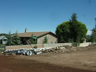
Coconino County public works have erected jersey barriers (concrete wall segments) around nearly 25% of the homes in areas affected by the July 20 flood.

Many more homeowners on the east side of the city have created sandbag barriers around their buildings and across yards or at the upstream point of their properties.

The homes were built on an alluvial fan where sheet flooding is the normal flow pattern. Most homeowners were unaware of the hazard and were caught unprepared when the heavy rains rushed down the slopes above that had been severely burned by the recent Schultz fire.

It's expected that revegetation of the burned area with grasses and low plants will take 3 years or so, during which time the homes are at higher risk of renewed flooding and debris flows.

A quick drive through neighborhoods offers a wide range of homeowner responses. Some have sandbag barriers completely surrounding their homes or outbuildings. Others are blocking doors only, or have one side of their house bagged. We saw lots of barriers that were partially built.

We heard that some residents are worried that their neighbors barriers will divert flood waters onto their properties and into their homes.

Coconino County flood mitigation efforts in Flagstaff


Coconino County is building channels and levees to protect homes on the east side of Flagstaff from future flooding that is exasperated by the Schultz fire that removed stabilizing vegetation above the populated alluvial fan. The county has spent about $2.1 million so far, and the Arizona Div. of Emergency Management has contributed another $2.5 million for the work.

Yesterday, AZGS geologist Ann Youberg was showing me the work she is doing on debris flows from the July 20 storm and it happened that State Emergency Managers were touring mitigation efforts by Coconino County. We tagged along and got to see the work underway on channels, debris basins, and individual home flood protection.

[right, the "Copeland Canal" that extends east from Highway 89. The light colored band on the slope in the background is part of the area burned by the Schultz fire, highlighted in part by the straw dropped by USFS helicopters in hopes of slowing runoff.]


[bottom, county and state emergency officials examine the Cinder Lake dry lake bed where flood runoff is brought by the Copeland Canal which is under construction.]

Debris flow assessment above Flagstaff


AZGS geologist Ann Youberg (right) is in Flagstaff, mapping and assessing the debris flows that accompanied the July 20 flood that damage so many homes in the Timberline and Doney Park subdivisions on the east side of the city. The floods and debris flows were a result of the denuded slopes from the recent Schultz fire.

Ann is working with Dan Neary and his team from the US Forest Service research lab based at NAU. I spent the afternoon in the field with Ann and Karen (USFS) and was astounded at the size of the debris flows on the mid-slopes (below the steep slopes of the upper mountain and above the alluvial fan where people live). [right, Ann Youberg points out the deposition from one debris flow triggered by flooding on July 20]

It's expected that it will take 2-3 years for vegetation to be restored on the upper slopes and naturally mitigate flooding and debris flows. In the meantime, the amount of sediment in channels and swales has the potential to be remobilized into lower channels during heavy rains, affecting how runoff is channeled down the alluvial fan where the residences are.

Tuesday, August 24, 2010

Arizona miners watching lawsuit over Nevada mining claim fee

Small miners across the West, including Arizona, are following the action in Nevada over the mining claim fee enacted by the state legislature earlier this year. An email from Laura Skaer, Executive Director of Northwest Mining Association forwarded a copy of the suit, and she reports that the lawsuit filed in Elko County by Claremont Nevada Mines LLC challenges the constitutionality of the mining claim fee: "The claim fee was included in AB 6 which was enacted to plug an approximately $850 million deficit in the State of Nevada’s budget. The lawsuit seeks a ruling declaring §47 (the claim fee section) of AB 6 violates Article X, Sections 1 and 5 of the Nevada Constitution and is void and unenforceable. It also seeks an injunction against the enforcement of §47 of AB 6 until the court rules on the constitutionality claim."

Reports are circulating in the mining community that other states are considering similar claim fees and taxes on "excess profits of mineral production."

Mining survey - AZ surges, NV dives


Arizona surged from 23rd to 17th in global rankings of areas favorable for mining, while Nevada suffered the biggest drop of any area, falling from 3rd to 10th, largely because of a new mining claim fee and threats of increased production taxes.

"Since 1997, The Fraser Institute has conducted an annual survey of metal mining and exploration companies to assess how mineral endowments and public policy factors such as taxation and regulation affect exploration investment. Survey results represent the opinions of executives and exploration managers in mining and mining consulting companies operating around the world."

Navajos oppose Hopi CO2 sequestration project


The Navajo Nation issued a press release last night announcing that the Tribe's Intergovernmental Relations Committee unanimously passed a resolution opposing the Hopi Tribal Council's "plan to research and allow" for carbon capture sequestration in the Black Mesa Basin. On Aug. 12, the Resources Committee passed the same resolution on a vote of 6-1. [right, WestCarb cross section through the test well previously drilled near the Cholla power plant near Holbrook]

Committee member Raymond Maxx said the Hopi Tribal Council recently approved the $5 million pilot project, working with four utility companies and the U.S. Department of Energy. The pilot project would store carbon dioxide from nearby power plants in an underground storage on Hopi land and near Navajo communities.

"The Hopi Tribal Council has selected a site in the Black Mesa Basin," Maxx said. "The proposed site is near the Navajo Aquifer (N-Aquifer), our precious water source. Once carbon dioxide is injected into the N-Aquifer, it will contaminate the water source we share with the Hopi people, our main underground water supply."

Maxx also said that as neighbors the Hopi Tribal Council failed to consult the Navajo Nation with its proposal. Passage of the resolution also urges the federal government to deny the final implementation of the carbon capture sequestration plan.

The AZGS has a small role in the project being run by the WestCarb consortium on Hopi lands. We will help examine the subsurface geology and evaluate the potential for CO2 storage.

When I was State Geologist of Utah, I ran a DOE-funded project in cooperation with the Navajo Nation to test the use of CO2 injected into small algal mound oil fields for enhanced oil recovery. The giant Aneth field, in the Utah part of the reservation, underwent CO2 injection for decades.

[taken in part from the Navajo Nation news release]

Copper at $10K by 2012?


Credit Suisse is forecasting the price of copper to increase 34% by 2012, reaching a price of $10,000 per tonne or $4.54 per pound according to a story on Mineweb.com. This is predicated on continued economic growth in China (which just passed Japan as the second largest economy in the world) and a modest economic recovery in the West.

If that sounds unrealistic, recall that in the past year, copper rose 150% from $1.30 to $3.30 per lb.

Arizona produces about 65% of the U.S. demand for copper and two potentially huge new mines are seeking regulatory approval to begin mining - Rosemont and Resolution.

Sunday, August 22, 2010

Gigawatts from solar and wind on mine tailings?


An article published today online in Miller-McCune magazine quotes Blair Loftis, national director of alternative and renewable energy for consulting firm Kleinfelder, as saying its possible that one particular mine in Arizona "with 10,000 acres of waste rock and tailings to produce up to 1 gigawatt of combined solar and wind power, about as much as an average coal-fired power plant." He doesn't say which mine.

The idea of using disturbed lands to host renewable energy plants has gained traction recently and the Arizona BLM office has a new program to pursue it. Mine sites often have the infrastructure in place to expedite development - power transmission, heavy duty roads, water sources, etc.

Univ. of Arizona has two experimental sites, at Biosphere 2 and their Sierrita research/teaching mine where the technology is being tested. [right, Nate Allen, sustainability coordinator at Biosphere 2, explains a demonstration site at Biosphere 2 showing how solar panels can be effectively mounted on steep slopes like mine tailings. Credit, UA]

Santa Fe impact structure 5-10 times bigger than Meteor Crater


I guess I missed the article from 2008 that described the evidence for a post-Paleoprotozoic (1.2 bya - 330 mya) impact crater in the area of Santa Fe, New Mexico. A story this month in Astrobiology magazine says the original crater was probably 6-13 km in diameter, or about 5 to 10 times the size of Arizona's Meteor Crater at 1.6 km.

The University of New Mexico is organizing a public field trip for summer 2011 to examine the exposures that document the impact structure. [right, shatter cone outcrop. Credit UNM]

Ref: S. Fackelman, et. al, (2008) “Shatter cone and microscopic shock-alteration evidence for a post-Paleoproterozoic terrestrial impact structure near Santa Fe, New Mexico, USA,” Earth and Planetary Science Letters 270, 290-299.

Governors of oil & gas producing states to meet in Tucson


The Interstate Oil & Gas Compact Commission (IOGCC) is holding its 75th anniversary annual meeting in Tucson in mid-November.

The commission is comprised of 36 oil and gas producing states with a mission of "balancing a multitude of interest-maximizing domestic oil and natural gas production, minimizing the waste of irreplaceable natural resources, and protecting human and environmental health- through sound regulatory practices." The Governor of each state is the official member but they typically appoint one or more representatives.

The meeting will be held Nov. 14-16 at the El Conquistador Hotel & Resort. Current IOGCC Chair Rick Perry, Governor of Texas, will preside.

Dale Nations, head of the AZ Oil & Gas Conservation Commission, is chairing the local host committee for the meeting.

Saturday, August 21, 2010

Peace in Big Chino water war?


The Prescott News quotes City of Prescott Deputy City Manager Craig McConnell as saying the Sierra Club and Center for Biological Diversity are withdrawing their lawsuit against the city over the Big Chino water project. He also said, "...Prescott, Prescott Valley and Salt River Project are filing documents with the court to mutually dismiss litigation according to the agreement we have."

It sounds like the agreement among the cities and Salt River Project to work out their issues cooperatively is coming to fruition. [map credit, City of Prescott]

Friday, August 20, 2010

Mining claim fee pits juniors against majors in Nevada


The battle over a new set of state fees on unpatented mining claims in Nevada appears to pitting the small miner against the majors.

A recently formed Nevada Mineral Exploration Coalition says "Section 47 of Assembly Bill 6 enacted by the Special Session of the Nevada Legislature (the Act)... increased the fee payable by the owner of an unpatented mining claim on the recording of a notice of intent to hold the mining claim. The increase in the fee is $70, $85 or $195 per mining claim depending upon the number of mining claims owned by the recording party." [right, mining claims at the end of 2008. Credit, NV Bur. of Mines & Geology]

The Act is a done deal, with the first claim payments due in June 2011. But one of my contacts says many of the small companies are threatening to not pay although he says the penalties for not doing so are unclear.

Opponents of the state fees say it was part of a deal negotiated by major mining companies to avoid elimination of the 5% cap on state production taxes.

ASU's Arrowsmith: "big one" is overdue in California


Southern California appears to be overdue for a major earthquake, according to a new study just published by a team including two ASU geology researchers, Ramon Arrowsmith and Olaf Zielke. The article in the September issue of GSA's Geology concludes:
The average time interval between the last six earthquakes that ruptured the San Andreas fault in the Carrizo Plain is 88 ± 41 yr. This is less than the time since the most recent A.D. 1857 earthquake, less than all reported average intervals of prehistoric earthquakes along the entire San Andreas fault, and significantly shorter than the 235 yr average used in recent seismic hazard evaluations. The new chronological data combined with recent slip studies imply that the magnitudes of the earthquakes that ruptured the southern San Andreas fault in the Carrizo Plain since ca. A.D. 1360 were variable, and suggest that the widely held view of rare but great surface rupturing earthquakes along this portion of the southern San Andreas fault should be reevaluated.

The article is getting a lot of attention in California. Ramon has posted a link to the full paper on his blog, along with balloon-borne photos and links to related papers. He says the figure at right is the key one.

Ref: Century-long average time intervals between earthquake ruptures of the San Andreas fault in the Carrizo Plain, California, by Sinan O. Akçiz, Lisa Grant Ludwig, J Ramon Arrowsmith and Olaf Zielke, Geology, doi: 10.1130/G30995.1 v. 38 no. 9 p. 787-790

Arizona has 3 of 20 least visited national monuments


Three national monuments in Arizona are among the least visited in the U.S. as described in a story in the LA Times:

#20 Chiricahua
#19 Tonto
#17 Pipe Spring

The least visited monument is Aniakchak, Alaska. Quite a few of the 20 are in New Mexico. [right, Dos Cabezas Mtns, Chiricahua Natl Mon. Credit, Natl Park Service]


Thanks to Geology.com for spotting this story.

Wednesday, August 18, 2010

Geologist appointed deputy supervisor of Coconino Forest


A press release from Coconino National Forest announces that "Kristin Bail has been named as the new deputy forest supervisor for the Forest and will officially begin mid-October.

In 1984 she joined the Bureau of Land Management in Oregon as a Cooperative Education student trainee in hydrology. She graduated from Washington State University in 1988 with a Bachelor of Science in geology and began her career as a hydrologist in the BLM’s Lakeview District." A longer bio is described in the release.

[right, Sedona area. Credit Coconino National Forest]

Monday, August 16, 2010

Two small Arizona quakes near Utah border


A tiny quake of magnitude 1.4 was recorded Sunday about 40 miles east of Fredonia. A week ago there was a magnitude 1.6 event south of St. George, possibly along the trace of the Hurricane fault.

USGS realignment to roll out this week


USGS Director Marcia McNutt is scheduled to start rolling out an internal realignment today at their Reston headquarters, then travel across the country over the next few days to describe the changes to staff in other centers.

The four USGS branches - Geology, Geography, Water, and Biology, are being replaced by a set of cross disciplinary science themes.

In general these are based on the themes described in the 2007 USGS Circular 1309

  1. Understanding Ecosystems and Predicting Ecosystem Change: Ensuring the Nation’s Economic and Environmental Future
  2. Climate Variability and Change: Clarifying the Record and Assessing Consequences
  3. Energy and Minerals for America’s Future: Providing a Scientific Foundation for Resource Security, Environmental Health, Economic Vitality, and Land Management
  4. A National Hazards, Risk, and Resilience Assessment Program: Ensuring the Long-Term Health and Wealth of the Nation
  5. The Role of Environment and Wildlife in Human Health: A System that Identifies Environmental Risk to Public Health in America
  6. A Water Census of the United States: Quantifying, Forecasting, and Securing Freshwater for America’s Future
A 7th theme on Data Integration will serve as underlying infrastructure to facilitate science interoperability.

Thursday, August 12, 2010

Kartchner Caverns in the running for "Favorite Park" prize


Arizona's Kartchner Caverns State Park is #7 in a national poll as "your favorite park." The winner gets a $100,000 grant from Coca Cola. You can vote as many times as you want before August 31 at http://www.livepositively.com/#/americasparks/vote.

Three readers asked yesterday that I post the link for the Coca-Cola site and urge everyone to go online and vote for Kartchner. They need a lot more votes to be in the running.

[right, Rotunda room, Kartchner Caverns]

Wednesday, August 11, 2010

News report on Sedona sinkholes broadcast

ABC Channel 15 ran a news story last night on Sedona sinkholes, based on the recent AZGS report by prominent Prescott geologist Paul Lindbergh. AZGS geologist Brian Gootee is featured briefly.

Sunday, August 08, 2010

More disasters or just more declarations?


There were more presidential disasters declared in the last decade "than in any other decade in more than 50 years, with an average of 56 per year. This is double the average from 1980 to 1989, when there were almost 24 a year, and 10 more than the 1990s with 46 per year," as reported in the National Emergency Managers Association (NEMA) 2010 Biennial Report.

NEMA said 59 major disasters were declared in the U.S last year compared for example to 34 in 1984. [right, Sabino Canyon, Tucson, following 2006 flooding. My photo]

A story about this in the Council of State Governments magazine Capitol Ideas asked the obvious question, are there really more disasters that require a major declaration or are there more political and societal pressures that are pushing the increase?

The answer is not easily resolved. There probably is a greater expectation by the public for federal assistance, but does that account for all the declarations or is there really an increase of natural disasters to some lesser extent?

Monsoon flooding around Arizona


It's a pretty robust monsoon season so far across Arizona. The sheet flooding across the low-relief areas around Flagstaff caught homeowners and officials by surprise [right, photo by Jeri Young, AZGS]. The denudation of the slopes from the Schultz fire upslope will make these areas more vulnerable until they are revegetated. Many homeowners are taking steps to build barricades and levees around their properties to get them through this season [bottom, photo by Jeri Young, AZGS]. But builders generally did not elevate the homes above the terrain, meaning that the area will always be at risk of sheet flooding.

Links to news reports:

Flagstaff is still recovering from floods in Timberline and Doney Park.
Unmapped flood zones need updating now [editorial]
Flood mitigation efforts resume over burn area


Flooded east-side [Tucson] area rejected levee in '93

Wall of water rolls down Nogales wash

Floods and tornado
funnels hit Navajo Nation

Debris flows follow Flagstaff's Schultz fire

An AZGS hazards team found debris flows when they inspected post-fire erosion occurring at the site of the recent Schultz Fire in Flagstaff last week, after heavy rains produced sheet flooding in the low-relief subdivisions at the base of the mountains.

Phil Pearthree, Ann Youberg, and Jeri Young from AZGS joined Deb Martin (USGS), Sara Brown (visiting UK grad student), Dan Neary (USFS), and Karen Koestner (USFS)

[Top photo: post-fire debris-flow snout, Weatherford Canyon, Waterline Road, Schultz Fire
.

Middle photo: post-fire debris flow deposits in Weatherford Canyon, Waterline Road, Schultz Fire.

Bottom: rills through mulch placed to mitigate erosion, Waterline Road, Schultz Fire.

All photos by Ann Youberg, AZGS]

The hillside erosion raises concerns about the efficacy of the reseeding and mulching efforts underway on these steep slopes in the near term to mitigate more erosion, flooding, and debris flows.


Friday, August 06, 2010

Continuing deformation from Baja's El Mayor - Cucapah quake


NASA's Jet Propulsion Lab reports that "New NASA airborne radar images of Southern California near the U.S.-Mexico border show Earth's surface is continuing to deform following the April 4 magnitude, 7.2 temblor and its many aftershocks that have rocked Mexico's state of Baja California and parts of the American Southwest."

[right, "the different shades in the image represent ground surface motions of up to a few inches upward or downward. Yellow shaded regions moved to the south or downward, regions in blue moved to the north or upward, and regions shaded in magenta showed no motion. Major fault lines are marked in red, and recent aftershocks are denoted by yellow, orange and red dots, with older earthquakes shown as gray dots." Credit, NASA/JPL]

The announcement also stated,
The April 4, 2010, El Mayor-Cucapah quake was centered 52 kilometers (32 miles) south-southeast of Calexico, Calif., in northern Baja California. The quake, the region's largest in nearly 120 years, was also felt in southern California and parts of Nevada and Arizona. There have been thousands of aftershocks, extending from near the northern tip of the Gulf of California to a few miles northwest of the U.S. border. The area northwest of the main rupture, along the trend of California's Elsinore fault, has been especially active.

Finding the center of Arizona not so easy


There is no standardized cartographic or land survey method for finding the center of the State of Arizona, according to the Arizona Professional Land Surveyors. Brian Fisher (azgeocenter2012@gmail.com), chair of the Geographic Center of Arizona Committee, briefed the Arizona Geographic Information Council yesterday that APLS is organizing events for the state's 2012 Centennial to engage the public in understanding better the complexities involved and in agreeing where to place a prominent monument to commemorate the location.

The "Journey to the Center of Arizona" project was prompted by a 3-part series in the Verde Valley newspaper in May.

The project web site has an in-depth analysis of the different mathematical approaches to finding the center of a body.

UA camera finds bulls-eye on Mars


The UA-run HiRISE camera on the Mars Reconnaissance Orbiter spotted this unusual "bulls-eye" crater on Mars. Project member Sarah Milkovich told Space.com that it could be either due to uneven erosion due to weak layers underlying the crater or a fortuitous second impact right in the center of the larger crater.

[Photo credit: NASA/JPL/University of Arizona]

Wednesday, August 04, 2010

Opponents to Resolution copper mine go unchallenged


The Arizona Silver Belt newspaper in Globe notes that opponents of the Resolution Copper mine project in Superior [right, #10 shaft. Credit, Resolution Copper], the San Carlos Apaches, the Inter Tribal Council of Arizona and the Arizona Mining Coalition, all showed up at public comment session to oppose water quality permits for the proposed $4 billion mine. But they asked where were economic development proponents from Globe-Miami, Superior, and Gila County:

However, none of the leaders or members of the Economic Development group appeared in person at the July 19th ADEQ Superior hearing to counter anti statements made by the three outspoken opponents of the mine . Nor did the EDC attempt to submit some kind of statement in support of the two water quality permits before the July 30 deadline.


[correction 8-21-10, 17:00 -my original post incorrectly labeled the photo as #9 shaft instead of #10. Thanks to Nyal Niemuth at ADMMR for spotting the error and sending photos of the differences.]

Satellite image of Flagstaff's Schultz Fire


NASA's Earth Observatory posted this satellite image of June's Schultz fire north of Flagstaff. The figure caption reads:

The Schultz Fire had burned an estimated 8,800 acres of forest north of Flagstaff, Arizona, as of June 22, 2010, and it remained totally out of control. Evacuations were in effect in the vicinity, but no structures had yet been lost according to the interagency Incident Information System (Inciweb) Website.

This image of the fire was captured by the Moderate Resolution Imaging Spectroradiometer (MODIS) on NASA’s Aqua satellite on June 21. Places where MODIS detected actively burning fire are outlined in red, and smoke drifts far to the northeast over the portion of the Colorado Plateau known as the Painted Desert.

The blaze looks like two separate fires, but an infrared-enhanced view shows a continuous burn scar (brick red color), with significant activity on both the northern and southern parts of the perimeter.

  • References

  • InciWeb. (2010, June 22). Schultz Fire. Retrieved June 22, 2010.

NASA image courtesy Jeff Schmaltz, MODIS Rapid Response Team. Caption by Rebecca Lindsey.

Geo-tweeting


Blogs are passe. Tweeting on twitter.com is now mainstream and the geoscience community is embracing it. [this sentence took 85 characters, well within the twitter limit of 140, so I could have tweeted it]

I'm following four twitter feeds, albeit intermittently:

GSA's geosociety at http://twitter.com/geosociety

AGU's theAGU at http://twitter.com/theAGU

Chris Rowan's Geoblogfeed at http://twitter.com/Geoblogfeed

and our own, maintained by Mike Conway, Chief of the AZGS Geologic Extension Service, AZGeology at http://twitter.com/AZGeology


Each of these is serving primarily as an aggregator of geo-news from a wide array of sources. With RSS feeds, these sit on the tool bar above my browser. A quick click, and I see
instantaneous lists of what's happening in the world of geoscience. Many of the tweets are links to blog posts or news headlines. Some report geologic events as they are unfolding.

Major contribution to Centennial Museum reported


At the Arizona Geological Society dinner meeting in Tucson last night, there was word circulating that Phoenix-based Freeport McMoRan has committed $1 million for the Arizona Centennial Museum. The Centennial Museum will be the reincarnation of the Arizona Mining and Mineral Museum that was transferred to the Arizona Historical Society last week in the first step of transforming it to its new role by 2012.

When Gov. Brewer announced plans for a museum to showcase Arizona's 5 'C's back in February, she said funding for it was expected to come from foundations, corporations, citizens, and grants.

Tuesday, August 03, 2010

Grandview Mine, Grand Canyon


Noted mineralogist Ray Grant dazzled the Arizona Geological Society monthly meeting tonight with an overview of the history, geology, and mineralogy of the Grandview copper mine in Grand Canyon National Park [right, credit Wikipedia]. It was the largest turnout I've seen at an AGS meeting in the past year or more.

The mine started in the 1890's below the Grandview location on the canyon's south rim. The park's first hotel was built there and the mining company may have made more profit from tourism than from mining. The deposit sits in a breccia pipe, with assays running 37% copper. One sample with 70% copper won an award at the 1893 Columbian Exposition.

In 1913 William Randolph Hearst bought the mine and hotel and ran them until selling to the Park Service in 1940.

Ray described 42 minerals found at Grandview, including a few found no where else. Grandviewite is unique to the site and only recently recognized as a new mineral. The pictures he showed of dozens of spectacular specimens explain why the Grandview mine is world-renowned and has been subject to unauthorized mineral collecting over many decades. Bat doors installed in 2009 are keeping collectors out now.

He and his colleagues are continuing studies of the minerals in the mine along with the hydrology and geology in partnership with the Park Service. Ray is also revising his popular Minerals of Arizona book that will include all of these incredible minerals.

Monday, August 02, 2010

Face on Mars disappears in hi-res photo


The infamous "Face on Mars" that prompted a generation of conspiracy theories about cover-ups of Martian civilizations, is not present in a closer, higher-resolution image of the site taken by UA's HiRISE camera on the Mars Reconnaissance Orbiter.

[1976 Viking image on left showing 'face' that disappears in image of the region captured by HiRISE and released last week. Comparison from Fox News. Credit, NASA/JPL/UA]

UA camera selected for new Mars mission


The UA-operated High Resolution Stereo Color Imager, or HiSCI, has been selected by NASA and the European Space Agency as one of the instruments to be carried by the ExoMars Trace Gas Orbiter, scheduled to launch in 2016. An announcement by UA says it "will study the chemical makeup of the Martian atmosphere with a 1,000-fold increase in sensitivity over previous Mars orbiters."

[right, "the UA’s High Resolution Stereo Color Imager, or HiSCI, features an innovative rotation drive for three-dimensional imaging. As the instrument orbits the Red Planet, it snaps pictures once a feature of interest on the surface below comes into view. HiSCI then swings around and takes more pictures of the feature as it passes overhead." Credit, UA]

HiSCI will be operated by the same team at the UA's Lunar and Planetary Lab that has been acquiring images from Mars using the HiRISE camera on the Mars Reconnaissance Orbiter.

AGU's Outstanding Student Paper Awards


The weekly geo-newspaper Eos reports Arizona geoscience students were among those who received Outstanding Student Paper Awards at the 2009 AGU Fall Meeting in San Francisco last December

Seismology
Christine Gans, University of Arizona, Tucson, Imaging the flat slab beneath the SierrasPampeanas, Argentina, using receiver function analysis: Evidence for overthickened subducted oceanic crust

Tectonophysics
David Pearson, University of Arizona, Tucson, Kinematic history of the retroarc thrust belt in the central Andes of Argentina at 24–25°S: Significant Andean shortening and sporadic foreland-ward deformation propagation

Hydrology
Maite Guariola- Claramonte, University of Arizona, Tucson, Regional vegetation die- off alters hydrological partitioning

Green Valley CAP extension center of mine debate


The recent decision by the Bureau of Reclamation to allow the CAP canal to be extended to the Green Valley area drew lots of news media attention today. Front page story in the Arizona Daily Star today by environmental writer Tony Davis offers a summary of the issues that has split the community. I also heard it on public radio on the drive home tonight as a lead story.

Rosemont Copper is paying for the extension and would get the water it needs for mining for the expected life of the mine. Community Water Co. gets a pipeline they cannot currently afford but the water would not recharge the downdropping water table caused by current water use by existing residents, farms, and other mines for the next 20 years or so. [right, regional groundwater level increase from recharge. Credit, Bureau of Reclamation]

The debate over the canal extension is complicated by its use for the copper mine.

Sunday, August 01, 2010

Arizona Mining & Mineral Museum transferred to Historical Society


The Arizona Mining and Mineral Museum (AMMM) was transferred from the Department of Mines and Mineral Resources (DMMR) to the Arizona Historical Society (AHS) effective midnight July 29, 2010, according to a post on the DMMR web site . This is in accordance with HB 2251, which was signed into law by Governor Brewer on May 6, 2010. The museum will be converted to the Arizona Centennial Museum in time for the state's celebration in 2012.

The notice from DMMR Director Madan Singh says "DMMR will remain in its present location through September 20, 2010 when it is planned to move to 1520 West Adams. Use the west door of this building, located on the north side of the parking lot behind 1520 West Washington (our present location). The DMMR offices and facilities will be closed between September 13 and September 24 because of the move; the website will also be off. Some facilities may not be available for a few days before and after the above dates."

The new location is just a couple hundred feet north of the present space.

Flash flood in Antelope Canyon

The Arizona (Flagstaff) Daily Sun reports that "Five members of a 12-person Swiss tourist group were injured Friday in a flash flood in the same canyon where 10 people drowned in a 1997 flash flood."

The tv station ABC15 in Phoenix, however, says it was 3 Swiss and 1 French national who were rescued but on Saturday. Another group of 8 were rescued reportedly from the Corkscrew area of the canyon further south.

This video posted on YouTube shows the slot canyon and why it could be dangerous in a flash flood.

Extension of CAP to Green Valley ok'd to recharge aquifer


The U.S. Bureau of Reclamation reaffirmed its approval of extending the Central Arizona Project (CAP) canal to Green Valley, to deliver Colorado River water to recharge the aquifer.

Inside Tucson Business says this has been fought by opponents of the proposed Rosemont Copper mine. The pipeline would be paid by mine owners Augusta Resources. The paper says pecan grove owner Farmer’s Investment Co. (Fico) is opposing both the pipeline and the mine. Pecan groves are among the largest water users in the area, which is undergoing notable ground subsidence due to pumping of groundwater [right, regional subsidence, from 2007 to 2008. Source, US Bur. of Rec].

BOR concluded that “plans for taking and using its CAP entitlement will not result in significant environmental impacts to the Green Valley/Sahuarita area, Upper Santa Cruz Sub basin of the Tucson Basin Aquifer, or the human environment in the vicinity.”

The BOR preferred alternative plan shows that the recharge by Rosemont could lead to a regional ground water level of 10s of feet, with a maximum of 100 feet at the center.