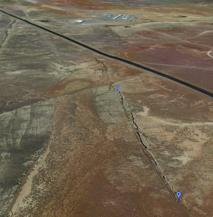
 The Google Earth view at right (NW at top) shows the trend of the 900 foot long fracture is a parallel to joints in the Kaibab Limestone and on trend with fractures across the region from Holbrook to the southeast and for miles to the north and northwest.
 George Billingsley with the USGS has mapped a number of small grabens in the area (see map below). Brian Gootee at AZGS reports that there are many of these ‘expansion joints’ in the Kaibab/Moenkopi rocks in the area.


The article doesn't say what the "recent activity" was, but I suspect it is the buzz from the Highway 89 slide, which is not at all related to these features.
ReplyDeleteI have been to some of these cracks and they are indeed impressive. A few years back I attended a talk by Peter Huntoon in Flagstaff. He had photos of himself and fellow spelunkers who had descended into one of these cracks more than a hundred feet, IMS. Peter would be a good resource on how these may have formed, and whether they are active.
My guess, from their apparent orientation, is that they are related to collapse, perhaps from salt dissolution to the north and northeast.
Our folks talked with with George Billingsley at the USGS. He has mapped these features and he characterizes them as “fractures – Open fracture.” They extend along a NW-SE trend from the Winslow area NW to Gray Mountain. Some measure 15 feet in width and the deepest extent 500 feet+ , reaching into the Coconino Sandstone near Wupatki. George has mapping pending that shows these features near Luepp. He attributes their formation to tensional stress of unknown origin; the fractures cut across pre-existing structures – monoclines, anticlines, and synclines. Most are on the Navajo Nation.
ReplyDeleteGeorge is unaware of any human injuries but the Navajo recount any number of incidences where cattle or sheep have fallen to their deaths.
The possibility of minor active widening of the fractures in this area is one that is apparently being investigated.
On the USGS Cameron-SIM2977, 1:100,000 scale map, fractures are described as “Fracture (0.5 to 3.5 m wide) without offset.” He has a category for fractures with minor offset, too.
Do we know how deep this crack is? I would be very interested to hear what the spelunkers who descended into this crack have to say. Before reading this article I had no idea this existed.
ReplyDeleteThese can be monsters. George Billingsley (USGS) reports that one fissure is at least 500 feet deep. They had a climber descend into it and he reached 500 feet without reaching bottom. We’ve received reports that people drop a rock and never hear it hit bottom. It sounds like nonsense, but if it really fall 500 feet…
ReplyDeleteLast, no report of human injuries, but many reports from Navajo residents regarding lost sheep and cattle.
Hmm, good job! This is really something!
ReplyDeleteThe Museum of Northern Arizona back in the 1930s explored one of these cracks by lowering someone down into them and they found bones of ancient animals such as giant bison and ground sloths on ledges deep down in the cracks. The report was published in the Notes of the Museum but I don't recall the exact issue.
Delete