Thursday, November 26, 2015

Using zeolites to remediate acid mine drainage - on latest episode of "Arizona Mining Review"


Zeolites are minerals comprised of silicon, aluminum, and oxygen that form frameworks full of cavities and channels that can work as "molecular sieves."

Ted Eyde, President of St. Cloud Mining in Tucson, joins us on this month's episode of Arizona Mining Review to describe how certain zeolites are being used to remediate acid mine drainage.

The November episode of Arizona Mining Review was webcast on Wednesday and posted to our YouTube Channel: http://www.youtube.com/user/azgsweb


AMR is underwritten in part by grants from the Mining Foundation of the Southwest and AMIGOS.

Sunday, November 22, 2015

AZGS Chief Geologist, Jon Spencer, retires after 33 years

Dr. Jon Spencer, Chief Geologist at AZGS, and head of the geological mapping program, retired on Friday after 33 years with the Survey.   We had an informal luncheon honoring Jon, with a small number of family, friends, and colleagues,  to thank Jon for his many contributions.   [Right, Jon - center- is flanked by former State Geologist Larry Fellows, left, and Steve Reynolds, professor of geosciences at ASU, right, who were instrumental in hiring Jon to the Survey's predecessor agency at the University of Arizona.  Photo by Stephanie Mar]

Jon's last geologic map, "Geologic map of the Cross Roads 7.5' Quadrangle and the southern part of the Gene Wash 7.5 Quadrangle," was officially released on Friday as an AZGS publication and it was formally dedicated to Jon in recognition to the understanding of the geology of Arizona.

Under Jon Spencer's leadership, the AZGS mapping program became one of the premier efforts in the country, often held up as a model for other states.     [Bottom, Jon listens to colleagues commenting on his contributions.  A framed copy of Cross Roads map dedicated to him stands at the right.  In front of him is a 1 to 12 scale photo of him in the field, mounted on cardboard, with multiple copies offered by Brian Gootee to the other mapping geologists to take with them to the field, so they also have Jon along with them.]

Citation: Spencer, J.E. and others, 2015, Geologic map of the Cross Roads 7.5' Quadrangle and the southern part of the Gene Wash 7.5 Quadrangle, La Paz County, Arizona, and San Bernardino County, California. Arizona Geological Survey Digital Geologic Map DGM 111, 1 map sheet, 1:24,000 scale.

More small quakes on the Intermountain Seismic Belt

There was yet another small quake in northwest Arizona, along the southern end of the Intermountain Seismic Belt [right, red lines are active faults]. This magnitude 1.8 event [blue dot in image] occurred at 4:04 p.m. on Friday, following two others [yellow dots in image] just before noon in the region.   Another tiny quake at magnitude 0.9, [orange dot in image] occurred this morning, at 2:10 a.m

Dr. Jeri Young, who runs the state seismic network for AZGS cautions that the preliminary locations from the USGS are off by 5-10 km, when the Arizona stations data are incorporated.
[Map credit, USGS]


Friday, November 20, 2015

Two more small quakes in northwest Arizona

 Northwest Arizona had its fifth and sixth small earthquakes in the last week and a half, today just before noon. A magnitude 2.9 event at 11:48 a.m., local time was followed ten minutes later by a magnitude 1.5 quake very close by that was likely an aftershock.    The events occurred about 33 miles southeast of Littlefield, Arizona, and are in the same area as a magnitude    quake that occurred on November 14.   [Right, the epicenters of today's quakes are in orange. Last week's event in yellow. Red lines on are faults. Credit, USGS]

The quakes are in the midst of a number of active faults that comprise the southern end of the Intermountain Seismic Belt and close to the Washington fault.


Tuesday, November 17, 2015

4th small quake in northwestern Arizona this week

We've had a small spate of small quakes in the northwest corner of the state this week with the fourth one occurring at 7:53 a.m, yesterday.    The earthquakes are still widely scattered and do not appear to be related.  The latest one was 17 miles south-southeast of St. George, Utah. [Right, the latest quake epicenter shown in blue.   The week's previous quakes are in yellow. Credit, USGS]


Monday, November 16, 2015

2 million page views

This blog passed the 2 million page views level today, so thanks to all of you readers.   It probably passed that point some time ago, but I did not start tracking analytics until a year into blogging.   

I've made over 4,100 posts since beginning, but this past year my blogging has dropped off precipitously.    That is a factor of being over-committed on projects, and a recognition that more viewers visit our Facebook page run by Mike Conway.  The Facebook page is actually better suited for a lot of the more regular announcements that I used to post here.

Our Facebook page also reaches out to a larger more diverse audience. Arizona Geology is still targeted to the geoscience community.    But I've also heard from a number of news reporters who follow the site to catch items that would be good stories.  

 So, onward!


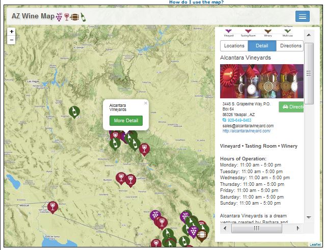
New interactive map of Arizona wineries, vineyards, and tasting rooms

Arizona's burgeoning wine industry is now showcased in a new online interactive Wine Trail Map, built here at AZGS as part of a new Arizona Wine Country page on the Arizona Experience website.

Three regions in Arizona are growing grapes for wine: Sonoita in Santa Cruz County, Willcox in Cochise County, and the Verde Valley in Yavapai County. View the Arizona’s Wine Trail Map.

The map shows wineries, vineyards, and tasting rooms in all three areas.    Each location has contact info, description of the wines, history of the facility, directions, and photos.  [Below, screen shot of the Alcantara Vineyards pop-up.  The writeup continues below what is visible in this clip.]


Three small quakes in northwest Arizona last week

Three small earthquakes were recorded widely scattered across northwest Arizona in recent days [right, yellow dots show epicenters of quakes recorded last week. Credit, USGS].

A magnitude 1.6 quake occurred on November 11, about 19 miles east-southeast of Boulder City, NV.
http://earthquake.usgs.gov/earthquakes/eventpage/nn00518536#general_summary

A magnitude 1.3 event occurred on November 13 about 21 miles south of Colorado City.
http://earthquake.usgs.gov/earthquakes/eventpage/nn00518829#general_summary

A magnitude 1.4 quake occurred on November 15 about 34 miles southeast of Littlefield.
http://earthquake.usgs.gov/earthquakes/eventpage/nn00518946#general_summary


There are no reports of any of these being felt.   It's also unlikely that they are linked geologically.


Sunday, November 15, 2015

My op-ed on geologic hazards published in Arizona Republic

The Arizona [Phoenix] Republic newspaper published my editorial piece today on geologic hazards in Arizona.  This was prompted by the Black Canyon City earthquakes on November 1 which were felt over much of central Arizona.  The online version  - http://www.azcentral.com/story/opinion/op-ed/2015/11/14/arizona-earthquakes-geology/75473784/ - has additional photos, videos, and live links to many of the geologic events I reference in the article.  [Right, earth fissure in the Queen Creek area, 2006. Credit, Bryan Macfarlane, AZGS]

I concluded that "We have only to look around us at the dramatic landscapes of Arizona to appreciate the power of natural events that throw up mountains and volcanoes, carve immense canyons and constantly sculpt the land beneath our feet.

The geologic forces that created Arizona also create hazards and risks for us. Recent earthquakes are just one reminder of that."
 
Last weekend I also did a live radio broadcast (KTAR, Phoenix and syndicated statewide) with Rosie Romero, host of "Rosie on the House" talking about earthquakes and landslides.   The show is podcast at https://www.rosieonthehouse.com/radio/what-renters-should-know, in Segments 3 and 4.


Wednesday, November 04, 2015

Aftershock from Black Canyon City quake felt in area


A magnitude 2.2 earthquake occurred last night at 8:33 p.m. about 13 miles north of Black Canyon City, Arizona, according to Jeri Young who manages the states seismic monitoring network at AZGS. We received reports from ranchers in the area who felt the ground shaking. This is the fourth felt event in the area over the past several days. This is likely an aftershock to the largest event, a magnitude 4.1 quake at 11:29 p.m. last Sunday evening, which was felt over a large area of the state and rattled the entire Phoenix metro area.   


The 2.2 event is the northernmost event on this map. (North is to the top of the map.)


Tuesday, November 03, 2015

Arizona earthquake funding denied

The USGS turned down our funding request to characterize the most active fault in Arizona to better understand earthquake hazards.   Ironically, the letter informing us that the proposal was denied, arrived just hours after a series of earthquake shook most of the population of the state.

AZGS proposed doing detailed work on the Lake Mary fault in northern Arizona under the National Earthquake Hazards Reduction Program.  The letter from the USGS program manager stated:
Your proposal ... has been recommended for funding by the peer panel that reviewed the proposed research. Unfortunately, the U.S. Geological Survey (USGS) Earthquake Hazards Program does not have sufficient resources available to fund your proposal in fY 2016.
Of the 211 proposals reviewed under this Announcement, the U.S. Geological Survey (USGS) will support 39 proposals; will place 39 proposals on hold pending a funding decision in January 2016; will decline to fund 52 proposals due to a lack of sufficient funds; and will decline to fund $1 proposals that were not recommended for funding by the peer panels.
 Arizona suffers from a widespread perception that we don't have earthquakes and thus are low on the priority list for resources to address this hazard and risk to the population.
 

Monday, November 02, 2015

4.6 million Arizonans shaken by quakes

More than 4.6 million Arizonans live in the areas where people felt the ground shaking from last nights earthquakes near Black Canyon City, according to information posted by Ramon  Arrowsmith, ASU geology professor, on his "Active Tectonics" blog -
http://activetectonics.blogspot.com/2015/11/links-and-commentary-on-earthquakes-11.html.  The estimate comes from the USGS.

Ramon's added a number of links to relevant background materials and made the observation that "the mapped active faults to the east (Horseshoe, Carefree, and Sugarloaf--all similar orientation."    We have not yet processed the first motions of the quakes to see what type and direction of movement is associated with the ruptures, and whether they correlate with the rough north-south alignment of the epicenters.

Ramon posted seismograms of the three events as recorded at ASU (right).