Thursday, October 18, 2007
USGS' 6 goals for the coming decade
The USGS identified 6 strategic goals for the coming decade in an article published this week in Science magazine (http://www.sciencemag.org/cgi/content/full/318/5848/200).
They include:
1. Understanding ecosystems and predicting ecosystem change
2. Climate variability and change
3. Energy and minerals for America's future
4. National hazards risk and resilience assessment program
5. The role of environment and wildlife in human health
6. A water census for the United States
The full report on the USGS plan is published in
USGS, "Facing tomorrow's challenges: U.S. Geological Survey science in the decade 2007-2017" (Circular 1309, USGS, Reston, VA, version 1.0, April 2007); available at http://pubs.usgs.gov/circ/2007/1309/.
Wednesday, October 17, 2007
States filling gap in science and technology
States are filling in the gaps in science and technology and related policy created by a waning investment and support at the national level. That's a conclusion I came away with from the past two days in a national convocation organized by the National Academies (Science, Engineering, Medicine) and others, to examine the growing role of states in science and technology.
While there has been widespread recognition in the past couple of years that the US is falling behind in science and technolog, it has been largely viewed as a national problem. Now, however there are many large, innovative efforts underway at the state level. States are seen operating as mini-nations in this arena, a concept that should not be surprising when you realize that state economies equal those of other nations.
Gov. Napolitano really brought this to national attention with her "Innovation America" initiative as head of the National Governor's Association last year (www.nga.org/center/innovation).
A new report by the Pew Center on the States and the NGA describes what's happening at the state level and Arizona is cited as one of the more innovative states with impressive results (http://www.pewtrusts.org/pdf/NGA_Report.pdf).
Tuesday, October 16, 2007
San Tan homes being built in fissure area
Today's East Valley Tribune carries a front page story about new homes being built in an area of known earth fissures in the San Tan area souteast of Phoenix (http://www.eastvalleytribune.com/story/99710).
The fissures appear on older AZGS maps and have been known by locals for years, prompting some to post a warning sign along the road in an old tractor tire.
A representative of the developer told the Tribune reporter that a well-known geologist was hired to verify there are no fissures on the property, but he couldn't remember his name.
Saturday, October 13, 2007
Arizona copper companies soaring
Two Arizona companies made it onto Fortune magazines list of 100 Fastest-Growing Companies 2007: Southern Copper (#9) and Freeport McMoran Copper and Gold (#19).
Southern had earnings-per-share growth of 83%, revenue growth of 67%, and total return of 83% (all 3-year annual rates). Freeport's numbers were 127%, 51%, and 44%.
Baseline magazine also just selected Southern Copper as the #1 company in the country at using information technology to increase productivity, with a return on IT investment of 1290%, adding $1.098 billion in value to the company. Southern Copper credited deployment of business intelligence software and Internet telephony.
Thursday, October 11, 2007
Arizona copper production up 3% to $5.6 billion
Employment in Arizona’s copper industry grew 19 percent to 8,200 jobs in 2006, and the industry’s total economic benefit to the state was up 34 percent to more than $4.7 billion, according to the latest annual study prepared for the Arizona Mining Association ("The Economic Impact of the Arizona Copper Industry 2006" - http://www.azcu.org/viewNews.php?item=7).
Arizona copper companies produced 787,236 tons of copper and other minerals with a total value of $5.628 Billion (59% more than in 2005).
Wednesday, October 10, 2007
U.S. critical mineral stockpile "ineffective"
A new report from the National Research Council concludes , "Neither the federal government nor industry have enough accurate information on supplies of minerals critical to the economy and national security," while a second new report says that, "the National Defense Stockpile of materials reserved for emergencies is ineffective for such purposes. Systematic approaches are needed to collect better data on supplies of critical minerals and to manage national security needs."
The reports and summaries can be read or purchased at http://www.nationalacademies.org/morenews/20071005.html
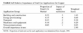
Copper rates a 3 on a scale of 1-4 in impacts from a supply disruption (see figure above), but it has the lowest supply risk of the 11 critical minerals studied, because so much in produced domestically (read that as "Arizona").
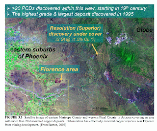
The study highlighted economic, technical, and political factors limiting supplies of critical minerals for national defense, including noting that urbanization has effectively removed copper reserves near Florence, between Phoenix and Tucson, from development.
The primary use of copper is in building and construction but the most critical national defense use is for telecommunications which uses 5% of the supply (see table).
Two Arizonans served on the NRC panels that produced these studies: Dr. Madan Singh, Director of the AZ Dept. of Mines and Mineral Resources, was on the committee for
"Managing Materials for a 21st Century
Military" and Dr. Mary Poulton, Chair of the
UA Dept. of Mining and Geological Engineering, was on the committee for "Minerals, Critical
Minerals, and the U.S. Economy.
Monday, October 08, 2007
Sabino Canyon debris flows on new Google Earth photos
Google Earth posted new photos of the Santa Catalina Mountains north of Tucson that show spectacular views of the debris flows that tore up much of the canyon in July-August 2006. Go to Google Earth and search on "Sabino Canyon."
The light colored streaks running from upper left to lower right are debris flow chutes. Stop 9 on the shuttle route is marked by a blue dot in the upper right. That location was buried by 8-10 feet of boulders and debris.
Notes from the AGS field trip to Zacatecas, Mexico
Participants on the AGS Ores and Orogensis field trip to silver mines in Zacatecas, Mexico, led by Peter McGaw, found their way there from the Tucson symposium via a myriad of pathways. My friend Tom McCrory made a fairly straightforward trip by planes from Tucson to Dallas, Mexico City, and Zacatecas before grabbing a taxi for the last 30 miles to the field trip jumping off point in Fresnillo. Pity the poor woman from Kosovo who went from the meeting in Tucson to Zacatecas by a 22 hour bus ride.
Tom, whose Spanish is nearly as poor as mine, says that by the end of the trip, he could shout "Donde esta mi muletas!" ("Where are my bags!") with the best of them. [He is third from the right in the back row, by the way]
Tom reports that, "The field trip went underground all three days they were there, including five hours in the largest producing silver mine in the world [note: in 2006, the Penoles' Proano (Fresnillo) mine produced 33.49 million oz Ag] What the picture doesn't show is the incredible heat and humidity near the working faces. In this mine they have intercepted five veins, the longest of which is 6.5 kilometers from east to west (typical precious metals ore shoots run less than one kilometer). As most of the district is under alluvial cover, and has never been explored with modern methods, it is entirely possible it could hold more than 10 percent of the entire world reserves of silver."
Thursday, October 04, 2007
Sputnik heralded geologic revolutions
The launch of Sputnik 50 years ago today is being rightly celebrated as the start of the space race and a shot across the bow of America's scientific supremacy. It also helped trigger the start of two geologic revolutions - plate tectonics and planetary geology. It was the synoptic views of Earth that galvanized a new generation to think seriously about the previously outrageous concept and start looking at geology on a global scale. And suddenly we had a dozen other worlds to compare to the Earth to understand just how unique the geology of this world is.
The excitement of seeing pictures from new worlds has been for me comparable to historical terrestrial explorers who found new lands and peoples.
Without Sputnik, there may not have been the U.S. investment in all areas of science in order to compete with the Soviets. There is a wistful hope among many scientists today for another Sputnik moment to galvanize the public and political leaders once again and recognize the importance of science to our lives, our well-being, and our national security. [right: geologist Harrison Schmitt on the moon]
White House calls for National Water Census
The White House Office of Science and Technology Policy (OSTP) released a study on the three national scientific and technical challenges to adequate fresh water supplies:
1. Measure and account for the Nation's water
2. Develop methods that will allow expansion of fresh water supplies while using existing supplies more efficiently
3. Develop and improve predictive water management tools
A major proposal is to develop a National Water Census. At last fall's GSA meeting, Gene Whitney of OSTP (the only geologist in the White House) gave a talk on the Census, describing it this way: "Such a census would require us to develop and adopt data collection, data communication, and data availability standards and protocols for all surface water, groundwater, and water quality measuring and monitoring systems nationwide. A census would integrate existing water monitoring networks to provide uniform water measurements nationwide, and would develop a strategy to establish regional and national priorities for the highest level needs for surface and groundwater monitoring in the U.S. Such a water census might also include implementation of the National Water Quality Monitoring System."
The full report, "A Strategy for Federal Science and Technology to Support Water Availability and Quality in the United States" is posted by the Office of Science and Technology Policy at
http://www.ostp.gov/nstc/html/_reports.html.
1. Measure and account for the Nation's water
2. Develop methods that will allow expansion of fresh water supplies while using existing supplies more efficiently
3. Develop and improve predictive water management tools
A major proposal is to develop a National Water Census. At last fall's GSA meeting, Gene Whitney of OSTP (the only geologist in the White House) gave a talk on the Census, describing it this way: "Such a census would require us to develop and adopt data collection, data communication, and data availability standards and protocols for all surface water, groundwater, and water quality measuring and monitoring systems nationwide. A census would integrate existing water monitoring networks to provide uniform water measurements nationwide, and would develop a strategy to establish regional and national priorities for the highest level needs for surface and groundwater monitoring in the U.S. Such a water census might also include implementation of the National Water Quality Monitoring System."
The full report, "A Strategy for Federal Science and Technology to Support Water Availability and Quality in the United States" is posted by the Office of Science and Technology Policy at
http://www.ostp.gov/nstc/html/_reports.html.
Tuesday, October 02, 2007
Water on Mars as rare as in Arizona
A special issue of Science magazine focuses on reports by Arizona planetary geologists Alfred McEwen (University of Arizona Lunar and Planetary Lab), WL Jaeger (USGS Astrogeology Team in Flagstaff) and their colleagues, in which it's concluded that "evidence for liquid water [on Mars] is rare and difficult to discern."
The collection of articles in the Sept 21 issue on the Mars Reconnaissance Orbiter report that fields of boulders up to about 2 meters in diameter occur in areas previously thought to be riverbeds and ocean floors. Some landforms thought to have been formed by flowing water are now seen as evidence of flowing lava.
Sounding more like Arizona every day.
Dr. Alfred McEwen discusses the findings in a related podcast interview at http://podcasts.aaas.org/science_podcast/SciencePodcast_070921.mp3.
ASU-authored geology textbook creating a buzz in educational circles
A new introductory geology text by ASU professor Steve Reynolds and colleagues is designed to address how students think, learn, and study. Although it was only published in June (too late for most professors to select it for fall classes) it's been picked up by at least four universities and is creating buzz in education circles because of it's innovative use of cognitive research in how visualization affects learning.
Exploring Geology by Reynolds/Johnson/Kelly/Morin/Carter (and published by McGraw-Hill) is built around nearly 2,700 photographs and illustrations laid out entirely in two-page spreads. Each two-page spread is a self-contained block of information about a specific topic.
It's organized differently from all the other texts I've seen as well. When Steve showed me a copy at last week's AGS conference, I wanted to run off with it, find a quiet corner, and pour though it. It's true: a good illustration is worth at least a thousand words.
Monday, October 01, 2007
Feature story on earth fissures and ground water
The Tucson Weekly for Sept 27 has 3 full pages dedicated to earth fissures and in particular, their potential to serve as conduits to ground water. See the full story by Sam Stoker at http://www.tucsonweekly.com/gbase/Currents/Content?oid=oid:101037.
This is their annual "best of..." issue which means it's widely read, but also snapped up from the newstands quickly.
Arizona Section of AEG approved
The national Association of Environmental and Engineering Geologists (AEG) approved creation of an Arizona Chapter at their board meeting on Friday. For the past 2+ years, we have had an AEG section in Phoenix as part of the Las Vegas-based Southwest Chapter. There is also a student chapter at the University of Arizona.
Section presidents Jessica Humble and now Ken Fergason, with great support from many others, have done incredible jobs building the section into a dynamic professional organization. The next question is now that we have an Arizona section, when will it be active in Tucson?
Subscribe to:
Posts (Atom)