Saturday, September 22, 2012

Water well registry online for Arizona


The Arizona Dept. of Water Resources announced that the GIS Well Registry web application is now linked to imaged records.  After completing your search from either the Search Wizard tool or the Web map tool, you can use the new Imaged Records button to view the well’s document.  You can access the Well Registry User’s Guide.

GIS web applications: https://gisweb.azwater.gov

Congrats to Karen Fisher, ADWR's GIS Developer, for  getting this online.


Friday, September 21, 2012

New home dedicated for earth sciences at ASU

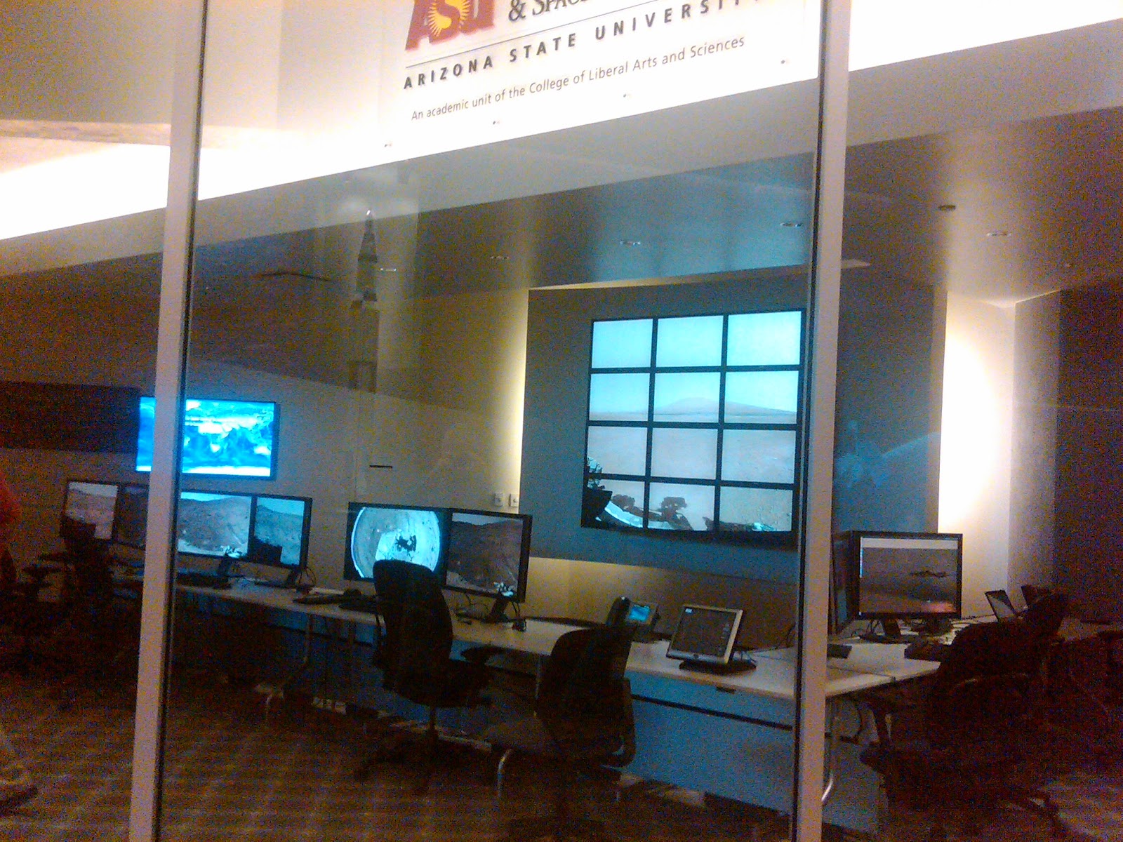
The new home of ASU's School of Earth and Space Exploration was formally dedicated on Wednesday with a grand opening ceremony and forum.  SESE shares the building with a number of engineering programs.

The Interdisciplinary Science & Technology Building 4 (ISTB4, right. Credit ASU) "is the single largest research building at ASU, with roughly 300,000 square feet of premier high-technology research laboratories, office areas, and collaboration spaces specifically designed to promote transdisciplinary team interactions."

The construction took over 70 million pounds of concrete (>20,000 cubic yards), 837 tons of structural steel, and 1,855,149 feet of wire (all of which had to be mined by the way).

The main floor is set up like an interactive science museum with a spectacular giant globe where visitors choose what planet-wide phenomena to view.  Video screens are everywhere, but your attention is drawn to the Mars operation center behind a wall of glass, with live feeds from the Red Planet.   A Mars rover sits just inside the main doors and a wide variety of ASU's extensive meteorite collection is on display on the second floor veranda.

Tuesday, September 18, 2012

Small quake east of Fredonia


A magnitude 2.1 earthquake struck Monday morning at 9:05 am local time, about 7 miles east of Fredonia, just south of the Utah border.   [Right, orange star marks quake epicenter. Location map from USGS]

Crunch coming on uranium supplies?

The mining industry has recognized for years that the world's nuclear power plants use more uranium than is being mined. The shortfall has been made up from stockpiles in Russia and other countries but that agreement ends in 2012.

An interview with mining analyst Alka Singh lays out the numbers:  433 currently operating nuclear power reactors around the world annually consume 177 million pounds (Mlb) of uranium. World  production was 130 Mlb last year.  The U.S.'s 104 operating nuclear power reactors used 55 Mlb while the U.S. produced only 4 Mlb.  [Right, highly enriched uranium.  Credit, US DOE]

Thus, the industry's rush to find and develop enough uranium resources to keep the plants fueled, and one reason that the breccia pipes in northern Arizona, which have among the highest concentrations of uranium of any deposits, are a strategic target for mining.


Sunday, September 16, 2012

G. K. Gilbert - "A Captain Bold"

The National Geographic Society is profiling their 33 founding members in recognition of their upcoming 125th anniversary, and published a short bio of Grove Karl Gilbert, one of the most influential geologists in the field, who did some of the early explorations of Arizona.  [Photo credit Wikipedia]

The article starts out, "Grove Karl Gilbert was considered by his own and future generations to be the greatest of all American geologists, and “a captain bold,” according to Australian geologist E.C. Andrews."

Intense battle over Florence copper project

Real estate developers have the support of Florence town leaders in opposing the proposed underground in situ copper leaching process.  The town has closed down the offices of Curis Resources, made copper recovery illegal within two miles of the town, and banned the use of the sulfuric acid in copper operations (but not other applications). The Arizona Republic's put together an overview of what looks to be one of the nastiest such battles in Arizona history.

The paper followed up with articles on the in situ process where a weak acidic solution is pumped underground to leach the copper out of the rocks and pumped back to the surface for recovery [right, credit Curis Resources], and another on some of the political back story

A Curis representative told the Arizona Mining Alliance luncheon crowd on Friday that they are moving forward with permits to start the copper project on state lands by next year.


Saturday, September 15, 2012

Arizona copper production since 1874


Arizona has produced 62.8 million tons or 125.6 billion pounds of copper during 1874-2010 per USGS, USBM, ADMMR, and AZGS publications, according to figures compiled by Nyal Niemuth in the AZGS Phoenix branch office.   About half of that was produced since 1978. 

World production through 2007 is reported by the USGS as 1.23 trillion pounds; 1.1 trillion pounds of that total is still in use because copper's recycling rate is higher than that of any other engineering metal.  By my calculation, Arizona is the source of about 10% of the total world production of copper.  [Right, native copper. Credit, USGS]

Web site promotes nuclear waste processing, disposal in Arizona


Proponents of processing spent nuclear fuel in Arizona set up a web site to promote the idea  - http://arizonanuclearsolutions.org - with a slide presentation at http://ansaz.files.wordpress.com/2012/08/aeef-powerpoint-presentation-for-arizona-nuclear-solutions.pdf.  The plan calls for burying the remaining nuclear waste in salt deposits in Arizona.

State Sen. Al Melvin is the spokesman for the group and summarized the proposals at the Arizona Mining Alliance luncheon in Tucson on Friday.

AZGS has identified and characterized salt deposits in the state at the request of Legislature members but this does not constitute an evaluation by us of the potential for waste storage or an endorsement of the proposal. [Right, significant subsurface salt deposits in Arizona.  AZGS]

Tracking mining-induced seismicity in Arizona

Our friends at Geology.comhttp://geology.com/news/2012/united-states-mining-seismicity.shtml reminded us that the USGS tracks mining-induced seismicity across the US, principally caused by blasting to break up the rocks.   The figure below shows a concentration around the Kayenta coal mine on the Navajo and Hopi reservations in the northeast and near the Morenci copper mine near Clifton.    It's not obvious why the Clifton area blasts extend to the southeast into New Mexico.  The USGS map does not show seismic events around Lake Mead that are supposedly quarry blasts.  [Right, mining-induced seismicity, Arizona-New Mexico, from 1997-2000.  Credit, USGS]

Thursday, September 13, 2012

State Highway 264 reopens after flood damage


 The Arizona Dept. of Highways re-opened State Highway 264 east of Tuba City after a section was washed out by heavy rains on Wednesday. The temporary fix allows travelers on the Navajo and Hopi reservations access to the cliff-side road until more permanent repairs can be made next week, according to news reports.

[Right, washed out section of road just to right of center. Credit, ADOT]


Sunday, September 09, 2012

Geologic mapping priorities set for next year


 AZGS's Geological Mapping Advisory Committee [right] met in Phoenix last week to set priorities for mapping projects for the Survey.   The 12 members come from state and federal agencies, and professional and trade associations across Arizona.

The group  reviewed proposals from the geoscience community and GMAC members for mapping in 11 different areas and the rationale for mapping each area.  The meeting is open with a few other geology representatives sitting in.   

The GMAC voted and the top choices are:
  • Tucson area aggregate mapping and database
  • Kingman area geologic mapping
  • Holbrook area geologic mapping
  • Lower Colorado River valley geologic mapping
AZGS Chief Geologist is using this list to identify specific quadrangles to propose for matching funding from the USGS Statemap program.   I'll share more details on why each area was chosen and what we hope to learn from the mapping.

Saturday, September 08, 2012

AZGS releases framework for geoscience 'big data' initiative

"Big Data" is the popular term for cyberinfrastructure and it's becoming one of the most significant disruptors in industry today, and on the verge of doing the same in the geosciences.

Early this week, AZGS released a 200-page report, "EarthCube Governance Framework: A Proposal for the Community," that was prepared for the National Science Foundation.      The report was prepared by the EarthCube Governance Steering Committee and additional EarthCube contributors since the June 2012 NSF EarthCube charrette. It is based upon the implementation the EarthCube Governance Roadmap that we presented there: to determine the management and organizational functions required to build the national cyberinfrastructure for the geosciences, and to engage the larger community about how to do this over the next six months. [Right, components of a given scientific community that have to be addressed in building cyberinfrastructure.   Credit, Carroll Hood, Raytheon; from the report]

The EarthCube initiative is the prototype for the high-profile NSF Cyberinfrastructure for the 21st Century (CIF21) program, and touted as one of the premier components of the White House "Big Data" effort.   The functions and guiding principles we compiled could serve as the basis for a solicitation from NSF to set up an EarthCube office to carry the concepts to fruition.

AZGS has the workshop grant from NSF to develop the initial roadmap and I chair the Governance Steering Committee.    AZGS researcher Genevieve Pearthree served as editor of both the roadmap and framework documents.

We've been on the road already this summer, carrying the concepts out to the wider geoscience and IT communities.  A number of workshops are being organized around the country over the next six months to align community needs with the EarthCube vision.


Friday, September 07, 2012

Geothermal energy workshop draws industry crowd

A crowd of about 50 showed up yesterday in the Capitol Executive Tower for a day-long workshop on geothermal energy in Arizona.  The morning session focused on ground source heat pumps (GSHP), with animated discussions about how to calculate their efficiency and cost savings, and how to get home owners over the long held myth that these heating-cooling systems don't work in Arizona.

The  afternoon session looked at the potential for developing geothermal power plants.  Arizona Public Service, the state's largest electric utility, and Ormat, the nation's largest geothermal plant developer, went through the requirements needed.

The workshop was organized by Leisa Brug, the Governor's Energy Policy Advisor and her staff.

I spoke in the morning giving an overview of the state's geothermal energy potential including power generation, direct-use (space heating, aquaculture, etc) and GSHP, and describing the National Geothermal Data System that we are helping build and deploy.   We got offers at the meeting from half a dozen companies to contribute data on their geothermal installations to the database for Arizona, that can help everyone better evaluate and calculate system requirements.

The day ended with a great roundtable among the group about what's needed to speed up geothermal energy development in Arizona.  At a minimum, the networking during the day offered some connections for sharing information and data and a consensus that further meetings of the group will be of great value.

Thursday, September 06, 2012

Swallowed by the haboob

I was heading home from the Capitol this afternoon around 4:30 and about 20 miles south of Phoenix the wall of dark rain clouds ahead turned to brown. 

The wind picked up and things started getting dusty.  But within seconds we disappeared into what I hear was a giant haboob.   Speeds dropped from 75 to 10 mph, flashers came on and there was an orderly migration off the highway, across the shoulder and over to the freeway fence.  I was in the middle of a small convoy that crept along carefully, everyone cautious about changing lanes or doing anything sudden that might catch our fellow travelers by surprise.  [Right, cell phone photo out the windshield taken at about 5 mph]

My wife Ann says she was watching the news when reports came in that this haboob was heading north and hit Chandler on the south side of Phoenix about 15 minutes after I went through it.


Sunday, September 02, 2012

Program set for Volcanism in the American Southwest conference

The latest agenda, circular and preliminary abstract volume for the Oct 18-20 Volcanism in the American Southwest conference are all on the conference website.


Hotels:  Evidently, Saturday is Homecoming at Northern Arizona University.  Hotels are rapidly filling up.  If you are not going on the field trip, this may not be an issue.  However, if you are staying in Flagstaff Saturday night after the field trip, you will want to get reservations made soon.

Abstracts:  The draft abstract volume is posted at the conference website.

Conference organizer Jake Lowenstern, USGS, says a Thursday evening dinner is being planned and the field trip is definitely happening. More later...

Saturday, September 01, 2012

Potash - the "pink gold" rush


Mineweb.com interviewed Fadi Benjamin, a mining analyst with Northern Securities Co., an investment bank based in Canada about a report from the International Fertilizer Industry Association that says "the fertilizer market is on the mend, with demand for potash rising 3.7% per year. Today, U.S. potash prices are at about $575 per metric ton (mt), compared with $380/mt last year."  Potash is used primarily for fertilizer.  The US imports 85% or more of its needs.

Benjamin argues that  farmers "stopped applying the mineral to cropland for a couple of years [due to high prices]. The holiday was possible because crops do not consume all of the fertilizer immediately, and the remainder stays in the soil as a reserve. But now, all around the globe, the potash content in soils is too low. The demand for potash has returned, and crop prices have significantly increased. We are now in a world of $7.90 spot corn prices, $16.65 spot soy and $8.89 spot wheat. It may take two to three years of aggressive potash application for North American soils to reach 2008 soil levels."

Three companies are currently exploring the Holbrook basin potash deposit in eastern Arizona.


Uranium isotope data from Tuba City dump

A new report from the USGS describes uranium isotope data from "analyses completed at Northern Arizona University for groundwater and solid-phase leachate samples that were collected in and around Tuba City Open Dump, Tuba City, Arizona, in 2008."
  

Ref:  Johnson, R.H., Horton, R.J., Otton, J.K., and Ketterer, M.K., 2012, 234U/238U isotope data from groundwater and solid-phase leachate samples near Tuba City Open Dump, Tuba City, Arizona: U.S. Geological Survey Open-File Report 2012–1126, 2 p.


Southern Copper $2 billion judgement upheld


 Mineweb.com reports that "Delaware's Supreme Court reaffirmed the Court of Chancery's decision to award $2 billion to Phoenix-based Southern Copper Corp. for "overpaying its corporate parent Grupo Mexico during its acquisition of Minera Mexico."

"The crux of their argument was that Grupo Mexico received more than $3 billion worth of Southern Peru stock in exchange for something that was not worth nearly that much, Minera."

The judge also awarded "the largest attorneys' fees ever awarded by Delaware Court of Chancery at a rate of $35,000 per hour for a total of $304 million."

Great Arizona Shakeout earthquake drill - drop, cover, hold on


In October 2012, communities throughout Arizona will participate in the first ever Great Arizona Shakeout to become acquainted with the recommended response in event of an earthquake: Drop, Cover, and Hold On

The Arizona Geological Survey and Arizona Division of Emergency Management are asking state and local authorities and school districts to participate in the ShakeOut event scheduled for 10:18 a.m. on Thursday, October 18, 2012

Arizona joins California, Idaho, Nevada, Oregon, Utah and Washington  in hosting an annual ShakeOut event. Last year, more than nine million people participated in ShakeOut events in the western U.S. Our goal with this statewide event is to engage at least 50,000 participants in a two-minute Drop, Cover, and Hold On drill  [Right, historical seismicity in Arizona, 1852-present.   Earthquakes > M=4.0]
 
While communities in Coconino, Mohave, Yavapai and Yuma counties--and to a lesser extent Cochise, Pima and Santa Cruz counties--are at greatest risk from earthquakes, no Arizona community is wholly immune from the shaking and damage that accompanies moderate- to large-magnitude earthquakes.
The Arizona Broadband Seismic Network recorded 131 earthquakes in 2011; most went unfelt. The largest events occurred near Clarkdale in central Arizona and were of magnitudes 3.7 and 3.6.  Faults in Arizona, surrounding states and Mexico are capable of damaging earthquakes up to magnitude 6.5 or 7.0.
The Arizona ShakeOut--like ShakeOuts in neighboring California, Nevada and Utah--is based upon a “Drop, Cover, and Hold On” drill.  This simple 2-minute drill has the potential to save lives and minimize injuries from earthquakes.  The Drop, Cover, and Hold On drill:
ü      Drop to the ground;
ü      Take Cover under a sturdy table or desk if possible and protect your head and neck;
ü      Hold On until the shaking stops.

The Great Arizona ShakeOut provides an opportunity to practice what to do before an earthquake occurs in your community. This two minute commitment can save lives. The ShakeOut is free and open to the public.